
Trondheim to Tromsø
Day 5: Trondheim to Fauske by train
07:30
There's no getting away from the fact that when travelling around Norway, especially in the north of the country, one needs stamina for long journeys. This is the 07:38 from Trondheim to Bodø (arrival 17:28) - distance 729km (453 miles). Putting this into a British context, London to Edinburgh is 393 miles.
The Nordland railway only has two trains a day working over its entire length with one day and one nighttime service. The line is one of the few in Norway that is not electrified.
Shortly after leaving Trondheim the train passes through Hell stations, which always amuses English speakers....
|
|
 |

The coaches used are second class only and are air conditioned with reclining seats. Most seats are arranged facing the direction of travel and are turned at the end of the journey. Almost all have a window view although some are slightly limited. Note that in Scandinavia there are no visible seat reservations, so ask the conductor if you haven't got a reservation or want to move seats as he will have a list of all reservations.
Our reserved seats were facing backwards, and also near some fussy Americans, so I spoke with conductor and we moved to so another carriage with seats facing forwards. Fran had been expecting to be bored on this long journey but in her words, "......read only one short story and played one game of scrabble the whole way as it was very varied scenery, from pastoral to fjord to mountains with snow and tundra."

11:35:
Another typical station building built from wood. The railway north of Trondheim was built in stages between 1882 and 1962 with the line to this station, Snåsa, opening in 1926.

11:40 Namsskogan
Whilst the first few hours of the journey are relatively pastoral, and often in sight of the coast, by the time the train is four hours into its journey the scenery is much wilder as seen here as the line heads up the Ramsdalen valley.

12:25:
South of Trofors: lakes, rivers mountains ....

13:14: near Mosjoen
.....and forest follow each other for mile after mile.

13:33: Drevattn
The railway has now come down to sea level by the Sørfjorden, and follows the shores of fjords to the industrial town of Mo i Rana with its metal industries.

14:49;
North of Mo i Rana the railway begins the long climb up the Dunderlandsdalen valley towards the Arctic Circle.

14:55:
Near Dunderland the railway is high above the river, with mountains rising to well over 1000 metres in the background.

15:45:
The railway and the E6 road climb to a summit near the Arctic Circle of just over 700 metres above sea level. It's quite a dramatic crossing of the line with winter still being much in evidence.

15:47:
The Arctic Circle line is marked by cairns on either side of the railway; it's on the left of the photo and the Arctic Circle visitor centre is by the road. The conductor announced the crossing of the line over the loudspeakers, the train slowed down and the driver blew his horn. Unlike on the Hurtigruten ships though, Neptune didn't get on board to pour ice down inside your shirt!

As the line begins its descent from the summit into the Lønsdalen there are dramatic views of the high mountains to the east which lie in Sweden - the border is less than five miles away at the Arctic Circle.

16:05:
More dramatic mountain scenery near Roekland.

16:14:
The view from the line above Rognan, before it starts to drop into the Saldalen valley and the coast.

16:43:
On the approach to Fauske the railway runs by the side of the Skjerstadfjord with views beyond of more 1000m plus mountains.

16:57
Our journey ended at Fauske nine and a half hours after leaving Trondheim. A short walk downhill brought us to the Fauske Hotel....

...with a view from our (upgraded) suite(!!!!) of the fjord. We had dinner in restaurant - halibut with lots of cucumber and large boiled potatoes!

We walked for a short way along promenade by the fjord and had some fun trying to photograph some gulls before they flew away. Then we had an early night: it was the first of five nights north of the Arctic Circle and the black-out curtains weren't very effective.
Day 5: Fauske to Narvik by bus and ferry


We left Fauske on the bus for Sortland (and Narvik) about ten to nine. The journey is one of continual superb views of mountains and fjords. It includes a change of bus in the "middle of nowhere" onto a second coach which goes to Narvik after crossing a fjord by ferry. The other bus goes onto a different ferry and then uses road bridges to reach Sortland in the Vesteralen islands. We would pass through Sortland later in the holiday. The journey from Fauske to Narvik takes about five and a half hours for the 248km journey but, with the ferry crossing in the middle, didn't really feel that long.

09:20:
The early part of the journey was in the worst weather of our entire holiday with light rain for an hour or so. This is looking down the Apsfjord with some fishermen's huts by the side of the road.

09:20
The journey to Narvik must count as one of the most spectacular road journeys in Europe. The E6 road passes through numerous long road tunnels and over a large number of road bridges. This one is over an arm of the Nordfjorden. The road is about to enter a long curving tunnel before emerging onto the bridge. The Norwegians have to do most of their roadworks in the summer so there were about half a dozen delays en route for re-surfacing work, often over very long distances with convoy operations in force. What was noticeable was the low speeds that are allowed on most roads - generally 30 or 50 km/h in towns and 80 km/h (50 mph) outside of towns but often only 60 km/h on roads such as the E6 which can be quite narrow in places.
The E6 starts at Trelleborg in Sweden and runs to Kirkenes in the far north of Norway. Between Fauske and Narvik it climbs repeatedly from sea level up over mountain passes and in several locations through long tunnels under the passes.

09:50
The Nordfolda is an arm of the Mørsvikfjorden

09:55
Looking across the Nordfolda to a village on the other side of the fjord.

10:00
Looking back across the Nordfolda.

10:15
The Strindnatvet lake.

10:22
It's not a good photograph but gives an impression of the sections where the road climbs over a pass with the mountains high above the road.

10:50
The Skilvatnet lake.
Shortly before we arrived at the Bognes ferry terminal our bus (bound for Sortland) pulled into a layby and the passengers for Narvik were transferred to another bus. The buses then headed down to the ferry terminal and drove straight onto the ferries. During the crossing, which lasts about half an hour, we went into the cafe for a sandwich and coffee.

11:55
Looking across the sea to the Lofoten and Vesteralen islands with the ferries between Bognes and Lødingen passing each other.

12:05
Heading across the Tysfjorden towards the Skarberget terminal.

12:25
After leaving the ferry, the E6 continues along the side of the fjord before...

12:40
....beginning the climb from sea level to over 300m through the mountains ahead.

13:07
After crossing the pass the road is now down at sea level with the Ofotfjord ahead.

13:15
Fortunately the weather was improving as the road followed the Ofotfjord towards Narvik.

13:20
The Skyombrua suspension bridge

13:25
The approach to Narvik.

13:45
Narvik is, of course, principally an iron ore loading port. It is linked to the iron ore mines in Sweden around Kiruna and owes its existence to the warming effect of the Gulf Stream which means that, unlike ports in Sweden on the Baltic, the sea never freezes.

The view from our twelfth floor room in the Narvik Hotel needs little comment. Narvik was virtually destroyed in WW2 by bombing so most buildings are post war.

Another iron ore train arrives headed by two of the most powerful locomotives in the world.

The signpost seems a bit arbitrary in its choice of locations. Why no London or Berlin?

12:05 am
We went to bed early and set our alarms for midnight to see the midnight sun. Unfortunately, it was cloudy although the sun's light was shining through gaps in the cloud.
Day 7: Narvik to Tromsø
We had a leisurely breakfast after the various coach parties had left. Then Stephen went to look at the railway ,although no trains seemed to be running because of engineering work, and to buy a very large memory card for his camera. Fran had a lazy morning in hotel admiring the view and playing scrabble.

The mountain above the town was still covered with cloud. It had been our plan to go up the cable car at midnight the evening before but clearly this wouldn't have been worthwhile.

This rather unusual sculpture in the town centre has the inscription, "Peace is the promise of the future."

Our room was on the twelfth floor of the somewhat futuristic looking Rica Hotel Narvik, whilst the view from the fifteenth floor is seen below.
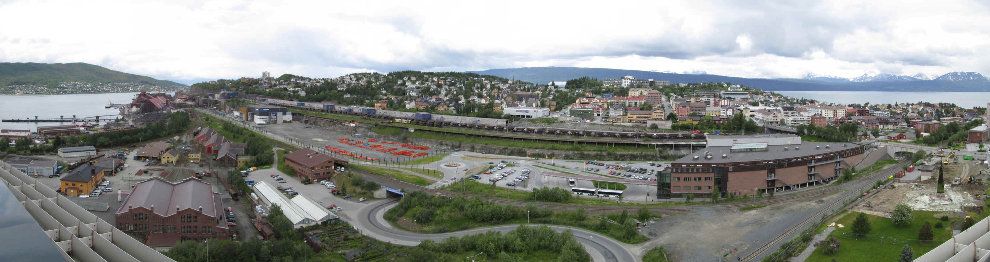
Click on the image for a larger photo. The iron ore loading facilities dominate the town.

After buying food for lunch we went for the bus to Tromsø at 12:50. The journey is 250km and lasts four and a half hours. As can be seen from the destination board this bus also has a connection to Alta (503km from Narvik)
The journey had views of more fjords and mountains but with some differences from the previous day's terrain - there were more wide open spaces and big skies. Again the journey didn't seem too bad for 4 and a half hours, with no breaks this time. There was just one opportunity to stand outside the bus for a few minutes. The numerous roadworks along the way meant there was no time for longer breaks and we actually arrived in Tromsø about 15 minutes late.


13:15
The journey starts by heading east from Narvik before crossing the Rombaksbrua suspension bridge over the Rombaken fjord.

13:27
Having crossed over the bridge, the E6 road merges with the E10, which runs from Luleå (in Sweden) to Leknes on the Lofoten islands. In Norway the road is known as King Olav V's road. The view is of the northern arm of the Ofoten fjord

13:40
This is Bjervik where the E6 and E10 part company. Our journey north nearly came to an end here when the driver tripped and almost fell....

13:50
The road now starts to climb from sea level to a pass at over 400m and crosses over the boundary between the Nordland province and into Troms.

14:10
The landscape is bleak with numerous lakes but the mountains are generally less dramatic than south of Narvik.

14:20
At Brandvoll the road is going downhill again alongside the Salangselva river.

15:09
In the middle of this wild area it comes as a bit of a surprise to arrive at Bardufoss which is a major military centre for the Norwegian Airforce and Coastguard. In the distance are mountains over 1400m above sea level.

15:35
The bus had a short stop Buktamoen where it made another bus connection. Passengers "in the know" disappeared to get a drink but no announcements were made to passengers about this obvious refreshment stop.

15:40
Crossing the Geadggeseatnu river north of Buktamoen.

15:55
Over to the east is the Takvatnet lake.....

16:00
.....whilst to the north west there's another range of 1000m plus mountains.

16:10
The road is climbing again to another pass at just over 200m....

16:20
.....before it drops back down to sea level by the Balsfjord.

16:25
At Nordkjosbotn the Tromsø bus makes a connection with a bus that heads further north along the E6 road towards Alta - arrival time there will not be until 22:25!!!
After leaving Nordkjosbotn the road to Tromsø (now the E8) begins to climb away from sea level...

16:45
.....until it is quite high above the fjord.

16:55
Then it is over another pass at about 200m....

17:10
....before dropping down to another arm of the Balsfjord.

17:20
The road climbs again to give superb views across the fjord...

17:30
...before dropping again down to sea level with the first view of Tromsø on its island.

17:35
Access to the city is over the Tromsøbrua bridge. Its 1039m long and the clearance over the fjord is 38m. The bus arrived on time at the small bus station at Prostneset in the city centre.

The northbound Hurtigruten was at the quayside so, as soon as we checked into our hotel, we went down to see it sail.

The 'Midnatsol' (Midnight Sun) sailing north a few minutes late at 18:50.
We had our evening meal at the restaurant in our hotel. It was pne of the Egon chain of restaurants and a bit like an English pub, but the food was good - cod and trout this time!

We left the hotel at about eleven to search for the midnight sun but failed to find a good vantage point, despite climbing quite high. Unfortunately, Tromsø is built on a hill which prevents you actually seeing the sun when it's low in the sky. However in this view, taken just before midnight, the sun is reflecting off the 1283m high Tromdalstind over to the east on the mainland.
Click here to go the next page - Tromsø
