|
|
The Gemsweg from Plattjen to Hannig
|
|
We
took the bus to Saas Fee for an early start on the gondola cable car to Plattjen
before walking the Gemsweg to Hannig. This is definitely the best way round to
walk the route for several reasons:
1)
The Mischabel peaks are always facing you and on the climb to Hannig you
can see the peaks above Saas Grund. Walking the route the opposite way the views
are much inferior.
2)
The descent from Plattjen is greater (but easy) at 666m whilst the
descent from Hannig is only 446m but is much steeper.
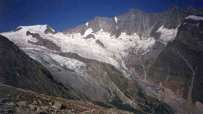
The view from near Plattjen .The picture shows the Mischabel range above Saas Fee.

The Saastal with Saas Fee to the left and Saas Grund down in the valley,.

Between Plattjen and Gletschergrotto
After passing under the Felskinn cable car the path descends more
steeply, crossing several streams from the west arm of the Feegletscher. The ice
at the end of the glacier can be seen towering above the path. About the half
way point of the walk lies the Gletschergrotto restaurant.

Crossing the glacial debris and moraines of the east arm of the Feegletscher.
From here the path heads up the side of the
lateral moraine before doubling back along the crest of the moraine. The second
half of the Gemsweg is also called the Ecology Trail and features notices boards
about different aspects of the geology, flora and fauna and economic life of the
area.

In the Triftbach valley with the Hohalmgletscher and Gemshorn
The Gemsweg now climbs
more gently up the Triftbach valley. The Hohalmgletscher comes into view with
the slopes of the Gemshorn rising to the northwest.
Crossing the Triftbach the path contours around a spur, to cross the
Torrenbach, before the final climb to the Hannig gondola cable car station at
2350m.

Climbing out of the Torrenbach valley towards Hannig
This is an absolutely superb walk and probably the most enjoyable around the Saastal.

The climb to Hannig cable-car station which can be seen on the right of the ridge.
