VIA ENGIADINA
Note: the maps are all based on those found on the SwissInfoGeo website.
The dotted red line is the route we walked whilst the dotted blue line shows the Via Engiadina sections that we did not use.


........which climbs slowly on the left bank of the Inn. Here the view is looking back to Zernez.

The track is mainly along the hillside but also through woods....

......to about 1750m before dropping down to Brail at 1622m.


.......and dropping down to the
station at Cinuos-chel-Brail at 1628m. Here we turned back on ourselves along
the road towards Zernez for about 100m before....

......going downhill into the village of Cinuos-chel to take the path across the river to S-chanf.

The River Inn at Val Flin

It could be difficult to cross here if the stream was in full spate.
There is then a delightful forest path before joining a paved lane for about 4 km to S-chanf.

This section was not a favourite part of
the walk! At S-chanf the nature of the river changes as the Inn has been
straightened and canalised in the flatter upper part of the valley.

S-chanf

Looking back to S-chanf
It’s mainly through woods and is easily graded. Our time from Zernez to Zuoz was about 6h including coffee and lunch breaks – about 5h walking time.

Zuoz
Stage 4 Brail to Zuoz via high level section
Back in 2007 when we walked the Via Engiadina we decided not to walk the "high level" section from Brail to Zuoz and, instead, made up our own route along the valley. In 2011 I decided it was time to complete the last "high level" part of the Via Engiadina that I hadn't walked in the Upper Engadine.

Leaving the station at Cinuos-chel - Brail at 10.40 there was a bit of back-tracking down the Inn valley to reach the Via Engiadina at Brail.

Opposite the station this lane leads uphill through woods...

....to then head along the valley side...

....to reach the hamlet of Brail.

Despite being tempted to have coffee in one of the hotels I pressed on..

..to the bus stop at the end of the village where a signpost points to the Via Engiadina. The way marking around Brail is somewhat confusing as the path seems to have both a low level and a high level route at this point. I just kept following the signs to Zuoz.

The path now climbs out of the village .....

.......heading back up the valley again.

Eventually this stile is reached and a curious signpost. The way forward to Zuoz is straight ahead but to read the sign you have to be peer around the pole as it's actually facing the field on the left - most un-Swiss to get things wrong. Perhaps the man putting up the sign put it in the wrong place/

The path climbs up the Val Punt Ota...

....and crosses a stream....

...before heading downhill again...

...and onto a forest track.

There's now a pleasant level section with good views....

....before a drop down into La Resgia. The curious building looks like a power station but is actually a large farm building.

Beyond La Resgia there was a short section of the Via Engiadina that was completely impenetrable, with nettles above chest height.

Fortunately, a short walk along the main road led to a lane up to the hamlet of Chapella ....

......where the path resumed in a more walker-friendly manner....

......before briefly going along the main road to this forest road junction.

The climbing now begins in earnest as the track climbs from 1670m at Capella to about 2050m, mostly through forests with little in the way of views.

For those who want to go higher a track to Alp Gnatshouls loops above the Via Engiadina but on a warm afternoon I was happy to keep on the main path to the left.

At Alp Laret the views open up ....

...before another section through woods.

Zuoz appears below...

.....and the path drops through more woods...

......to reach this path junction. Zuoz is straight on whilst the path downhill leads to...

.....the village of S-chanf.

The Via Engiadina heads down into the lovely village of Zuoz. It had taken me just over four hours from Cinuous-chel - Brail.
Stage
5 Zuoz to Samedan


Zuoz

...... which leads to the winter sports area.

Beyond this it’s along an undulating and, in places, quite steep mixture of forest paths and.....

.....field tracks with several streams to cross.

The highest point of the day’s walk is reached at Plaun Grand at 1955m, an area where plants and animals are protected by law.

The Inn valley from above Chamues-ch

There is a drop down to cross the Albula pass road, using a staircase with a rope handrail.

Chamues-ch
The path then follows the road downhill for about 200m......

.....before falling down to the Bach Ova d’Alvra at a bridge. The way is then through pleasant forest paths to join a forest road.


Bever
Stage 6 Samedan to St Moritz and Maloja
(both
valley and Via Engiadina paths)
We had decided that the best way to complete the walk between Samedan and the head of the Engadine at Maloja, in view of Fran’s feet problems, was to use the valley paths. These actually provided some of the most enjoyable and spectacular views of the whole walk. We broke the walk into two sections; a short afternoon walk form Samedan to St Moritz and a full day walk from St Moritz to Maloja.
1) Sameda

We walked this route over two days. The first day, from Samedan to St Moritz, was little more than an afternoon stroll and could easily be added to the St Moritz to Maloja session to make a whole day's walk.

Leaving Samedan we took the path to Celerina, along the left bank of the Inn.

Looking up the valley towards the Bernina Pass.

We took the Celerina path as far as a wooden bridge and then followed the signs to Lej da Staz across the bridge.

The next part of the walk is across the valley floor meadows along wide tracks, sometimes paved.

The path passes the ruins of San Gian church (note this photo was taken on a different day to the rest of the photographs).

The railway is crossed and the path climbs through woods to the lake.

Lej da Staz

Then it is along a paved lane to St. Moritz Dorf and the Lej da S. Murezzan.

Lej da S. Murezzan
St. Moritz main feature is its lake and the mountain backdrop of Piz Julier and Piz Nair. Our time from Samedan to St. Moritz was 1h 30m.
2) St Moritz to Maloja via the valley


The next day we started from St. Moritz station and walked along the lakeside to St. Moritz Bad.

Looking back towards St Moritz

From near the Signalbahn cable car station a broad path/ cycle track signposted to Silvaplana goes past the Olympic ski jump.....

... as far as Lej Marsch. Here we took a path signposted Surlej (1h) which climbs up through the woods......

......to another lake, the Lej Nai. At point 1864 a path to the right of the lake is signposted Surlej (30 m).

This path then drops down to reach the village of Surlej. A short walk down the road towards Silvaplana leads to a bridge over the end of the Lej da Silvaplauna at Crap de Sass.

The Schloss (castle) of Crap da Sass and beyond Lej da Silvaplauna. From here a broad cycle track follows the lakeside to Segl/Sils. Confusingly (until you realise it) both these names are used for the same location, one name being Romansche and the other German.

Lej da Silvaplauna looking up the valley.

Lej da Silvaplauna looking back towards the Crap da Sass.
The walk along the lakeside is about 1h 30m and on a sunny day was very busy, especially with cyclists, who expect you to get out of their way! At the end of the lake, we took a path that leads along the edge of woods to Segl/ Sils Maria past the Furtschellas cable car station. A short distance along the paved lane leads to the village of Sils Maria with its numerous hotels.

.......to reach a path that heads across meadows to the end of the next lake, the Lej da Segl. The signposts suggest that it is 1h 45m to Maloja. My guide book also stated that the path is almost level – it is NOT! In two places it climbs up quite high above the lake to avoid cliffs.

The path starts at water level but climbs quite steeply in places through woods before....

.....dropping down about halfway along the lake.......

.......to the small hamlet of Isola where a torrent cascades down from the Val Fedo.

Isola

What the Swiss do on a sunny day - the restaurant at Isola

Beyond Isola the path turns into a track. This view is looking back down the valley. Eventually the path comes to the outskirts of Maloja where it was just a few minutes walk to the bus stop. Our walking time from St. Moritz had been about 5h 30m.

The outskirts of Maloja and the Lej da Segl.
Despite what we’d thought beforehand this day’s walk had been a real highlight, but do walk it when the sky and lakes are blue!
3) Bever/ Samedan to Sils Baselgia via the Via Engiadina
The normal way to walk the section of the Via Engiadina from Bever to Maloja appears to be to stop at the Signalbahn cable car station above St. Moritz and resume from the same place. This makes two day’s walk of about 5h to 5h 30m. However, the circumstances I found myself in meant that I needed to get much further on than the Signalbahn on the first day, so that I could have a short walk on the second day. I therefore decided to attempt to walk from Bever to Sils Baselgia on the first day, and then continue to Maloja on the morning of the second day.


Leaving Bever I omitted the loop around the town in favour of joining the Via Engiadina just across the river. The track rises through woods to reach the outskirts of Samedan at Muntarüsch (1723m).

Once clear of the woods there is a view of Samedan.

The climb then begins with a vengeance as the forest track climbs in loops steadily to the farm at Muntatsch (2186m).

As the path rises higher there are increasingly spectacular views of the Bernina mountains. Beyond the farm the track turns into a delightful path.....

.....which loops its way around the slopes of Piz Padella (2856m). There’s a sudden right turn at a junction as the path makes its way up to the high point of the walk at Munt de la Bes-cha (2489m) underneath some cliffs.

Looking back towards Muntatsch with the mountains near the Albula Pass in the background.

There’s then a steady, and occasionally very steep fall.....

.....down to the gondola cable car station at Marguns, which I reached after 3h from Bever, about half an hour faster than earlier signs indicated.

Having dropped down to 2273m the walker is then faced
with an unremittingly steep and somewhat soul-destroying climb uphill, on a rough
track, to the Corviglia funicular station reached 3h 30m from Bever. The view of
the spectacular range of 3000m mountains in the background does help somewhat
even if the foreground is dominated by winter sports equipment!
After break at the restaurant at Corviglia, I decided that it would be possible to reach my planned destination in a reasonable time. The Via Engiadina drops down the rough vehicle track almost to the Signalbahn station.

St Moritz and its lake

Thankfully there are several sections where there’s a footpath instead.

The path then
heads off towards Alp Suvretta looping around the slopes of Piz Nair, with its
cable car going to the very top.

At the farm buildings the path drops down, leaves the path to the Suvretta Pass and doubles back on the other side of the Ova da Suvretta stream.

Beyond here the path climbs around the lower slopes of Piz Julier and becomes increasingly stony as it crosses small boulder fields.

The views over towards Piz Corvatsch (3295m) with its glaciers become increasingly spectacular.

To add further interest there are the remains of World War One fortifications built to protect the Julier Pass road.

The path now drops down a staircase to the Julier Pass road.....

......which runs between Silvaplana and Chur....

.....before joining a forest path, falling gently down all the way to Sils/Segl Baselgia with the Lej da Silvaplauna in view. The time from Bever was exactly seven hours including two short breaks.
4)
Sils Baselgia to Majola via the Via Engiadina

The following day I rejoined the Via Engiadina at Sils Baselgia.

It is a steady climb through woods and over a series of rocky sections....

.....with super views over the Lej da Segl and the mountains beyond.

The path then climbs steeply underneath some cliffs before dropping to reach the hamlet of Grevasalvas.....

......which was used for the filming of one of the many versions of “Heidi”. The farm track beyond the hanlet is followed up hill to another small hamlet at Blaunca before heading off across meadows towards Maloja.

The final
section took place in rain with a thunderstorm rolling around the surrounding
mountains, giving a suitably dramatic ending to the walk. Finally there’s a steep,
rocky and in places a little tricky descent into Maloja – for me the second
ending to our walk across the Engadine.

Maloja in the rain
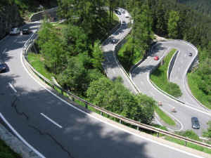
That afternoon Fran joined me for a bus journey along the Passo del Maloja road to Chiavenna in Italy. If you get as far as Maloja take this journey or you won’t appreciate that Maloja is actually situated at the top of an almost sheer valley wall at the head of the Val Bregaglia. We lost count of the number of hair pin bends. It really is an incredible journey and unusual in that it's the only pass in the Alps with only one ramp up to the summit.