MUNROS BY PUBLIC TRANSPORT
![]()
Although I drive a car I hate doing so unless absolutely necessary.
As of December 2022 I've now climbed 190 Munros. For about 115 of these I have used public transport in the form of ScotRail, Citylink, local service buses or, occasionally, I have hired a taxi to get to the start of the walk.
For the remaining 75 Munros that I have climbed I've travelled by train to locations such as Aviemore, Fort William and Pitlochry and hired a car locally, therefore avoiding the long drive up from my home in Middlesbrough. Unless you live in Scotland it's likely that you will have to find accomodation so why not use public transport to get there?
I have hired a car because some of the hills I want to climb are almost impossible to do so without a car. Now that I'm 70 my energy levels don't allow the really 'long walks in' that they did in the past!
Whilst there are some disadvantages to leaving the car in the garage at home, I do feel that using public transport can add something to a walk - there's no guilt at clogging up the roads and, the more buses and trains are used, the more likely it is that services will continue or improve. One disadvantage to using public transport is that you sometimes have to be really aware of the time as you don't want to miss your train or bus at the end of the day!
Realistically, it will never be possible to climb all the Munros using public transport but, for many walkers, that target is unachievable anyway. There's no way I'm ever going to have a "head for heights" to climb some of the Munros!
Please note that public transport time continually change so do check before travelling. I'm afraid I haven't the time to continually check whether the times I've quoted are still valid.
Let me explain the criteria I've used to work out whether a Munro can be climbed using public transport.
--------
Many of the walks can be tackled in a day from the Central Belt of Scotland. Where this is possible I've usually stated it.
In many cases it is necessary to stay overnight in the area at a youth hostel, bunk house, hotel or bed and breakfast. Bothies do not count!
Generally public transport will be direct (or very close) to the village where the accommodation is situated. There are one or two places, such as the Glen Affric youth hostel, where you will have to walk from the nearest bus stop carrying food and sleeping bags. This is the accepted method for car based walkers so I've included them in my total.
I have accepted longish "walk-ins", sometimes along roads, provided the route appears safe and is no more than about 2 hours. Where I don't think it is safe, but might be possible, I have stated this, but not counted them in my total. I've not suggested the use of bicycles for the obvious reason that these aren't generally popular on buses!
Sometimes it makes sense to move from one place of accommodation to another at the end of the walk, in order to make transport easier the next day.
I've used timings from the SMC guide book supplemented by other guides where necessary to calculate whether my suggested method will work. It is important to know how long you take for a walk compared to guide timings.
The symbols next too each hill name will be self explanatory:
![]() Accessible by public transport although sometimes requiring more effort than
normal.
Accessible by public transport although sometimes requiring more effort than
normal.
![]() These
hills can
be climbed using public transport but require quite "long walks in".
These
hills can
be climbed using public transport but require quite "long walks in".
![]() Impossible or very difficult to access using public transport.
Impossible or very difficult to access using public transport.
--------
Now to reveal all
It is possible to climb 212 out of the 283 Munros without using your car. For the record that is 75%, which is more than enough to keep most walkers busy for a long time.
PLEASE NOTE TIMETABLES CHANGE SO ALWAYS CHECK WITH THE OPERATOR OR GO TO THE TRAVELINE OR NATIONAL RAIL ENQUIRIES WEBSITE
I accept no responsibility for any problems you might have using this information
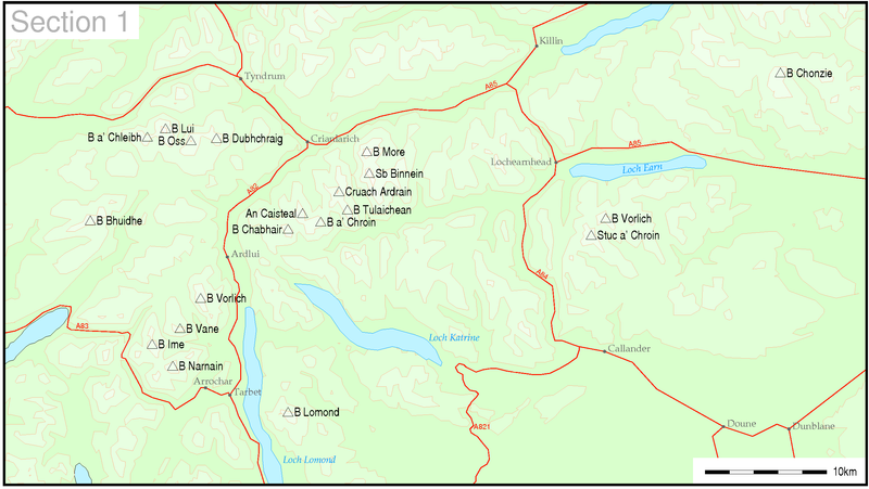
Section 1 Loch Lomond to Loch Tay
All maps are copied from Wikipedia under the freely usuable "public domain" policy. A donation has been made to Wikipedia to support its work in making knowledge freely available to all.
All 20 hills are accessible by public transport (Ben Lomond only by ferry)
Public transport in this area is generally quite
good especially in summer.
To avoid repetition the following are the main options:
ScotRail services from Glasgow stop at Arrochar and Tarbert, Ardlui, Crianlarich and the two Tyndrum stations - Tyndrum Lower is on the Oban line and probably is the best for walkers. Upper Tyndrum is on the Fort William line and is quite high above the village.
Citylink provide services from Glasgow to Oban, Campbeltown, and Fort William.
Summer only Citylink services from Edinburgh, Dundee and Perth operate to Crianlarich and Tyndrum via Killin which run end of May to end of September.
A good service operates from Stirling to Callander and from Perth to Crieff. (Precise details can be found on Traveline's website which includes all operators' routes)
Kingshouse Travel operate five services a day from Callander to Lochearnhead and Killin Mondays to Saturdays with a very limited Sunday service.
Beinn Bhuidhe (948 m) ![]()
Start from either the bus stop in Cairndow road end junction or the Cairndow Loch Fyne oyster restaurant bus stop
Citylink Oban/ Campbeltown service.
Ben Lomond (974 m) ![]()
|
This hill climbed using public transport but before I started taking photographs for this website |
For a daytrip using the 0640
Citylink bus
from Glasgow to Tarbert it is possible to catch the 0845
waterbus from Tarbert to Rowardenan which returns to Tarbert at 1645 with
connections back to Glasgow.
Alternatively, for later start to the day stay, overnight in Tarbert before getting the waterbus the next
day.
Beinn Narnain (926 m) ![]() and Beinn Ime (1011 m)
and Beinn Ime (1011 m) ![]()
|
This hill climbed using public transport but before I started taking photographs for this website |
Start from Arrochar or Arrochar and Tarbert station
Citylink Oban/ Campbeltown service to Arrochar
Ben Vane (915 m) ![]()
Start Sloy power station
Citylink Fort William service stops at Sloy - note there is a cafe/ toilets at the visitors centre here whilst waiting for the return bus!
Could also start/ finish at Arrochar and walk through the forest in Glen Loin to the bridge near Coiregrogain – use Citylink Oban/ Campbeltown services.
Ben Vorlich (943 m) ![]()
Start from Ardlui station
Train or Citylink
Beinn
Chabhair (933m) ![]()
Use the Citylink Fort William service to Inverarnan.
An Caisteal (995 m) ![]() and
Beinn a' Chroin (940 m)
and
Beinn a' Chroin (940 m) ![]()
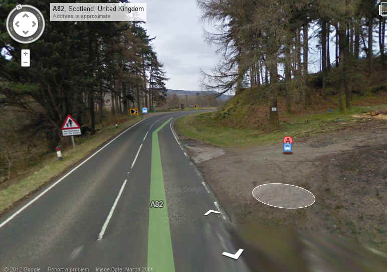
Walk from Crianlarich on wide verge of A82 (about 25 minutes to start of walk)
Train/ bus to Crianlarich.
Cruach Ardrain (1046 m) ![]() and Beinn Tulaichean (946 m)
and Beinn Tulaichean (946 m) ![]()
Walk from Crianlarich on wide verge of A82 (about 25 minutes to start of walk)
Train/ bus to Crianlarich.
Ben More (1174 m) ![]() and
Stob Binnein (1165 m)
and
Stob Binnein (1165 m) ![]()
Since the postbuses no longer run this hill is slightly more difficult to reach. Citylink buses do use this route but are unlikely to be prepared to stop at this point. It is 3.5km along the A85 from Crianlarich station to Ben More farm but there are wide verges and it is a safe road to walk along
Combine with Stob Binnein.
Beinn a' Chleibh (916 m) ![]()
Start from Tyndrum
Train/ bus to Tyndrum
Ben Oss (1029 m) ![]() , Beinn Dubhcraig (978 m)
, Beinn Dubhcraig (978 m)
![]() and Ben Lui (1130 m)
and Ben Lui (1130 m) ![]()
Start from Tyndrum.
Train/ bus to Tyndrum.
Use West Highland Way to get to Dalrigh
The Citylink bus may be prepared to drop you off at Dalrigh.
Ben Chonzie (931 m) ![]()
From Crieff
A walk of about 22km return from Crieff
Frequent all day Stagecoach service 15 from Perth to Crieff and Comrie. Get off at Crieff Monzie Road end. The walk to the the dam car park in Glen Turret is about 6km along country lanes.
Ben Vorlich (985 m) ![]() and Stuc a' Chroin (975 m)
and Stuc a' Chroin (975 m)
![]()
Start Callander or Lochearnhead
To reach Lochearnhead take the bus from Stirling to Callander and then Callander to Lochearnhead
A better alternative is,
I feel, to walk from Callander (see the walk on my website)
Section
2 River
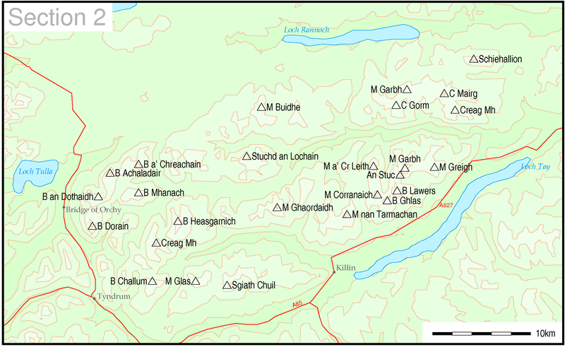
18 hills out of 26 are possible using public transport
Schiehallion
(1083 m) ![]()
This hill is one for the real public transport Munro bagger!!
It's probably possible to climb Schiehallion by staying in either Kinloch Rannoch, Tummell Bridge or Aberfeldy and using the school bus between Aberfeldy and Kinloch Rannoch to reach the junction of the road to Braes of Foss with the B846
The Aberfeldy to Kinloch Rannoch school days service 895 runs twice a day leaving Aberfeldy at 0650 and goes past the junction between the B846 and the lane to Braes of Foss about 0715. The return to Aberfeldy passes the junction at about 17:05.
The other alternative is to stay in Kinloch Rannoch or Tummel Bridge and take the 0745 bus arriving at the junction at 0815 and then catch the bus back at about 1605.
It's also possible to stay in Pitlochry or Strathtummell and connect into/ out of these two services using the Pitlochry to Kinloch Rannoch bus although this means a very early start just at 0610 with the return being at 1718 (Mon/Wed/Fri only in summer Wed in winter) or at 1943 every day.
Càrn
Mairg
(1041 m) ![]() ,Càrn Gorm (1029 m)
,Càrn Gorm (1029 m)![]() , Meall nan Aighean (981 m)
, Meall nan Aighean (981 m)![]() and Meall
Garbh (968 m)
and Meall
Garbh (968 m) ![]()
No
public transport
Ben
Lawers (1214 m) ![]() , An
Stuc (1118 m), Meall Garbh (1118 m) and Meall Greigh (1001 m)
, An
Stuc (1118 m), Meall Garbh (1118 m) and Meall Greigh (1001 m) ![]()
Beinn Ghlas (1103 m) ![]() ,
Meall
Corranaich (1069 m)
,
Meall
Corranaich (1069 m) ![]() and Meall a' Choire Leith (926 m)
and Meall a' Choire Leith (926 m) ![]()
Since the Ring of Breadalbane bus service finishe din 2016 the only way at present to climb these hills using public transport is by getting the schooldays only service 893 that runs between Killin and Aberfeldy and stay at the Lawers Hotel (for two or more) nights.
Killin dep 0740 and Aberfeldy dep. 1530. These pass the Ben Lawers Hotel .
Aberfeldy has a good bus services from Perth
Meall
nan Tarmachan (1044 m) ![]()
No Public transport.
It would theoretically be possible to use the morning schoolbus service 893 from Killin to Milton Morenish caravan site and then walk up the C road to the start of the walk at NN 605383 and then return and pick up the return school bus. You would have from about 08:00 to 16:30 to complete the walk.
Meall
Ghaordaidh (1039 m) ![]()
This hill can be accessed from the minor road up Glen Lochay from Killin to the normal start point at Duncroisk. The walk in will add about 9 km to the day but as the hill walk is only about 10 km it is an obvious possibility.
Stuchd
an Lochain (960 m)
![]() and Meall Buidhe (932 m)
and Meall Buidhe (932 m) ![]()
No Public transport.
A
truly determined walk might combine it with Meall
Ghaordaidh by dropping down to Dalchiorlich and climbing the hill from there
Creag
Mhòr (1047 m) ![]()
Creag Mhor can be climbed from Tyndrum by following the West Highland Way to Auchtertyre and then the track up Gleann a'Chlachain, cross the watershed beyond Cam Chreag and then to the summit of Creag Mhor. It's about 10 to 11km from Tyndrum.
Beinn
Heasgarnich (1078 m) ![]()
It's
another 4km further from Creag Mhor to Beinn Heasgarnich with another 400m
descent and 450m ascent. On the return the re-ascent over Creag Mhor could be
avoided by contouring round the hill but it's likely to be quite a demanding
walk.
Meall
Glas (959 m) ![]() and Sgiath Chuil (921 m)
and Sgiath Chuil (921 m) ![]()
Since it's unlikely that the Citylink buses along this route will be prepared to stop at the normal starting point for this walk at Auchessan is the only other option appears to be to stay at the Luib Hotel. To get to these hills requires a round walk of about 17 miles. First walk east along the A85 to Ledcharrie and then on a C class lane to Auchlyne. Here take the estate road that parallels the Auchlyne West Burn. When it ends climb the two hills and then return the same way.
The alternative starting at Auchessan requires a walk of 4 miles along the A85 from Crianlarich, both at the beginning and end of the day and Google Streetview shows sections of the road without good verges.
Ben
Challum (1025 m) ![]()
Beinn
Dorain (1076 m) ![]() and Beinn an Dothaidh (1004 m)
and Beinn an Dothaidh (1004 m) ![]()
|
This hill climbed using public transport but before I started taking photographs for this website |
Public transport options couldn't be better. Bridge of Orchy station for the train and the Bridge of Orchy Hotel for Citylink services.
Beinn
a' Chreachain (1081 m) ![]() and Beinn Achaladair (1038 m)
and Beinn Achaladair (1038 m) ![]()
This is a walk I did in summer 2008 when I persuaded the Citylink driver to drop me off just beyond the white girder bridge near the end of Loch Tulla. There's a pull in to a lorry loading area which the driver might stop in if he thinks it safe. Otherwise I was told the bus would stop at the large parking area just up the hill at Grid Ref 308453. Then it's just a case of walking back down the A82 to the start of the lane to Achallader Farm.
Don't
expect to be picked up here though so if you return the same way you'll need to
walk the 4km back to Bridge of Orchy along the verge. It's wide enough to be
safe.
Beinn
Mhanach (953 m) ![]()
I climbed this hill with the Beinn a' Chreachain and Beinn Achaladair but it's a bit of a marathon. It's probably better to start the walk from Bridge of Orchy and use the West Highland Way to reach the start of the walk at Auch.
Section 3 Strath Orchy to Loch Leven
![]()
23 hills out of 26 are possible using public transport
Beinn
a' Chochuill (980m) ![]()
![]()
These hills can easily be climbed from Loch Awe station on the Oban line. Arriving on the first train from Glasgow (1047) and leaving on the evening service (1850) gives plenty of time. (see my walk description for details)
One important detail is that there is a good sidewalk/ broad verge along the A85 so it's perfectly safe to walk to the start of the walk proper near the A85/ B8077 junction.
Similarly, the Citylink Glasgow to Oban service stops at Loch Awe and will give you eight hours. The timing point is at St Conans Rd junction which is a little further west than the station, but I'm sure the bus would stop at the Post Office near the station
Ben
Cruachan (1126m) ![]()
Ben Cruachan can be climbed from Falls of Cruachan station (open only in summer timetable period end May to end September) on the Oban line.
Citylink buses also pass this way
Ben
Starav (1078m) ![]()
No public transport
Glas
Bheinn Mhor (997m) ![]()
No public transport
Beinn
nan Aighenan (960m) ![]()
This hill should be possible from Bridge of Orchy, although it's a long walk past Victoria Bridge and Loch Dochard (perhaps it would be best to stay at the Inveroran Hotel). The Glasgow bus arrives Bridge of Orchy at 0850 and the return leaves at 2015. There's also a Glasgow train at 1855.
Stob
Coir'an Albannaich (1044m) ![]()
Again it should be possible to climb this hill from Bridge of Orchy and Victoria Bridge. Transport times as above.
Meall
nan Eun (928m) ![]()
Comments as for Stob Coir'an Albannaich - some reports suggest combining these two hills.
Stob
Ghabhar (1090m)
![]() and
Stob
a' Choire Odhair (945m)
and
Stob
a' Choire Odhair (945m) ![]()
By taking the 0700 Glasgow to Uig bus as far as Bridge of Orchy there is sufficient time to climb these hills and be back in time for either the evening return bus or train. (see my walk description). I would suggest using the road between Bridge of Orchy and Victoria Bridge rather than the West Highland Way in order to save time. The Glasgow bus arrives Bridge of Orchy at 0850 and the return leaves at 2015. There's also a Glasgow train at 1855.
Meall
a' Bhuiridh (1108m) ![]() and
Creise
(1100m)
and
Creise
(1100m) ![]()
The 0700 Glasgow to Uig bus arrives at the timing stop at the White Corries ski centre at 0908 . In summer the 0900 from Glasgow arrives at 1118. In winter the return buses are at 1502 and 1957 but in summer there are more - 1447, 1547, 1747 and 1957 After climbing the hill a visit to the Kingshouse Hotel could pass the time. I'm assured by the drivers that they will stop at the road end to the hotel if you stick your hand out!
Beinn
Sgulaird (937m) ![]()
This hill lies just off the A828 Oban to Fort William road which is served by West Coast Motors. Take the bus to Creagan Bridge Roundabout, and walk along the C class road on the north shores of Loch Creran to the normal starting point for the walk at Druimavuic. This is 3 miles from the bus stop or about one hour. The return climb time from here is about 5 hours so it should be possible to the entire walk in 7-8 hours.
Local service 405 leave Oban Monday to Saturday at 0658 and 0728 to Creagan Bridge Roundabout arrive 0728 and 0802.
On Saturdays and non schooldays (Monday to Fridays) it runs as service 405 at 0712 arrive Creagan 0744
On schooldays there is a return from the bus stop (with shelter) at Creagan Bridge Roundabout at 1633.
On Mondays to Saturdays in summer Service 918 (Oban to Fort William) leaves Oban at 0840 (arrives Creagan Bridge at 0910) and returns from Creagan Bridge Roundabout at 1557 and 1957.
The winter service return journey is at 1852 only.
If arriving on the 405 at 0728 it should be possible to be back by about 1545 giving time to catch the 1633 back to Oban.
On the 918 arrival ar 0910 you'd be back at about 1710. This gives plenty of time for a meal at the nearby Creag Inn before catching the 1957 bus back to Oban from the stop near the roundabout. Google maps shows a stop at the quarry near the inn but I would be inclined to walk the extra few hundred metres to the roundabout where there is a layby and a shelter and street lighting.
NOTE: I've included a link to the time I attempted to climb Beinn Sgulaird using public transport. I ran out of time largely because of weather conditions but it is certainly possible to climb the hill by catching an early bus from Oban.
Beinn
Fhionnlaidh (959m) ![]()
No public transport
Stob
Dearg (Buachaille Etive Mor) (1021m) ![]()
and Stob
na Broige, (Buachaille Etive Mor) (956m) ![]()
The Glasgow to Fort William and Skye buses will usually drop you off at the bottom of the Devil's staircase at Altnafeadh "providing it is safe to do so......" A more secure option would appear to be to ask for the Kingshouse Hotel and walk along the West Highland Way - this adds about an hour to the walk.
Do not expect the bus to stop for you at Altnafeadh (although it might do!!) as there doesn't seem to be a safe stopping place. For the return journey it's better to walk back to Kingshouse where they will stop.
For timings of buses see Meall a' Bhuiridh and Creise above.
Check with the driver when you board as they seem to vary in their willingness to stop.
Stob
Dubh, (Buachaille Etive Beag) (958m) ![]()
and Stob
Coire Raineach, (Buachaille Etive Beag) (925m) ![]()
My comments are much the same as for Buchaille Etive Mor. There is another parking area just beyond Altnafeadh, which is more convenient for these hills, and is on the south side of the road, so the drivers will probably stop there on the way out. Again I'd suggest you walk back along the short distance of the A82 to Altnafeadh and use the West Highland Way back to Kingshouse for the return bus.
Sgor
na h-Ulaidh (994m) ![]()
The walk starts from Glencoe village, which is very well served by Stagecoach buses from Fort William, as well as the Citylink Glasgow to Fort William and Skye services. The start of the climb is about three kilometres east of Glencoe village on the A82 - probably not a pleasant start or end to the walk; it might be more enjoyable to walk round via the Clachaig Inn.
Sgorr
nam Fiannaidh (Aonach Eagach) (967m) ![]()
I've put this hill separately to Meall Dearg as, by doing so, it avoids having to cross the Aonach Eagach ridge - no chance of me ever doing that!
Meall
Dearg (Aonach Eagach) (953m) ![]()
My comments below (in italics) about how to climb this hill have been left but I now feel the best way using public transport is to walk from Kinlochleven using the local bus from fort William and Glencoe village. The walk described below starts along the West Highland Way
Another possibility would be to ask the driver of the Fort William to Kinlochleven bus to drop you off at Caolasnacon bridge (near the caravan park) which the drivers have told me they will do.
An approach from Glencoe village with its Citylink and Fort William to Kinlochleven bus services is another option. From the junction of the A82 and B863 it's just under 5km to the bridge along a track from Bridge of Coe through woods and across the hillside. There's then about 1.5km along the B863 to the starting point just east of the bridge. Google Earth satellite shows a clear path starting from the road although it doesn't seem to continue very far.
Bidean
nam Bian (1150m) ![]() and
Stob
Coire Sgreamhach (1072m)
and
Stob
Coire Sgreamhach (1072m) ![]()
Hopefully the Citylink driver will drop you off at one of the car parks near "The Lost Valley".
Quite whether they will pick you up is another matter. Perhaps it would be better to retreat down to the Clachaig Inn and get the bus back the following day from Glencoe village.......
Sgorr
Dhearg, (Beinn a' Bheithir) (1024m) ![]()
and Sgorr
Dhonuill, (Beinn a' Bheithir) (1001m) ![]()
Citylink's Glasgow to Fort William and Skye services, together with Stagecoach frequent buses from Fort William to Glencoe all serve Ballachulish village. There is also a bus stop and shelter at the south end of the Ballachulish bridge. If boarding the bus here to go south drivers have told me to stand at the end of the bridge so that you can be seen clearly as the bus comes across the bridge
Section 4 Loch Linnhe to Loch Ericht
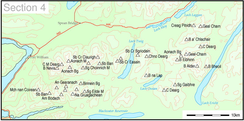
31 hills out of 34 are possible by public transport
For many of the walks in this area ,unless you are prepared to start very early from Glasgow and return very late, it's probably best to base yourself in the area rather than travel from lowland Scotland for the day.
Once in the Fort William and Ballachulish areas, bus services are surprisingly useful for walkers and, in some cases, better than when I climbed the hills in the area some years ago.
To avoid repeition, below is a summary of services which will be of use to walkers from Fort William. Please note that only those services that are likely to be of use to walkers are noted.
Glen Nevis services
Service 41 Stagecoach service 41 provides buses to Glen Nevis Upper Falls (Grid Ref approx. 144684) and runs between 3 and 7 times a day. The bus stops at a turning point just before the road crosses the river. Monday to Friday buses leave Fort Wlliam at 0842, 1005 and 1045 and return from the Lower Falls at 1518 (Monday to Fridays in school holidays only - they need the bus elsewhere in term time, unfortunately) and then 1718 and 1910. Saturday buses are at 0840 and 1045, with returns at 1518, 1718 and 1910. There are also buses as far as Glen Nevis youth hostel at 0705 (Mon-Sat) and 0805 (Sats only) which could also be useful. Sunday buses are less useful: 0805 to the hostel and then a first bus at 1120 to Lower Falls, which is far too late for most walks in the glen. The return buses are at 1340 and 1725. |
Nevis Range services
|
Service 41 also serves the Nevis Range gondola cable car. Now purists might argue that using the cable car is cheating when climbing hills but, given that there are several Munros where you can get even closer to the summit by driving, I'd disagree. The cable car takes you up to 655m, whilst Aonach Beag's summit is at 1234m and Aonach Mor's is 1221m. This still seems a pretty respectable height gain........ In any case this is how many hill walkers in the Alps tackle their summits. They use transport to get up the boring lower parts through the forests and enjoy the walk in the higher reaches of the mountain. That sounds just like the approach from Nevis Range. An additional bonus is that you don't have to compete with lunatic mountain bikers! Anyway those determined not to use the cable car can use the path through the forests or, better still, do a traverse from Glen Nevis. Opening times are 10 am to 4 pm all year with extended hours in July and August from 10 am to 6 pm. Service 41 actually runs from Roy Bridge to Glen Nevis via Nevis Range and Fort William and provides a roughly two hourly service so may even take you back to the youth hostel if you time it right. Fort William Monday to Friday departures are 0725, 0900, 0940 and 1140 with returns from Nevis Range at 1430, 1630 and 1830. Saturday services are at 0725 and two hourly 0940 to 1740. Buses leave Nevis Range at 1430, 1630 and 1830. Sunday buses from Fort William are two hourly from 1000 returning from Nevis Range at 1420, 1620 and 1805 |
Kinlochleven services
|
Service 44 Stagecoach operate an almost hourly service between Fort William, Ballachulish and Kinlochleven. Journey times vary slightly but are about an hour. The Monday to Friday service is, inevitably, slightly less useful due to the demands of school buses. There are buses from Fort William at 0800, 0847 and then hourly until 1447 when there is a gap until 1717, 1817, 2005 and 2240. Return journeys useful to walkers are at 1442 (in school holidays), 1542, 1812, 1912, 2055 and even one at 2328! Saturday services are simpler: From Fort William at 0642, then hourly from 0842 to 1742, 2200 and 2240. Returns from Kinlochleven are hourly from 0940 to 1840 and then 2055 and 2328. On Sundays there's an 1110 from Fort William arriving at Kinlochleven at 1202 returning 1405 and 1805 so what could be achieved is a little limited. |
The
Mamores
Sgurr
Eilde Mòr (1010 m) ![]() and Binnein
Beag (943 m)
and Binnein
Beag (943 m) ![]()
Use the bus to Kinlochleven
Binnein
Mòr (1130 m) ![]() and
and
![]()
Use the bus to Kinlochleven
Stob
Coire a' Chàirn (981 m) ![]() and An
Gearanach (982 m)
and An
Gearanach (982 m) ![]()
Use the Glen Nevis bus to the Lower Falls terminus (be warned you'll have to cross the wire bridge near Steall Hut)
I'd choose to walk from Kinlochleven for this walk and combine with An Gearanach to avoid the "bridge"!
Am
Bodach (1032 m) ![]()
|
This hill climbed using public transport but before I started taking photographs for this website |
Use the Glen Nevis bus from the Lower Falls terminus or walk from from Kinlochleven.
Sgurr
a' Mhàim (1099 m) ![]()
|
This hill climbed using public transport but before I started taking photographs for this website |
Use the Glen Nevis bus to the Lower Falls terminus.
Mullach
nan Coirean (939 m)
![]() and Stob
Bàn (999 m)
and Stob
Bàn (999 m)![]()
|
This hill climbed using public transport but before I started taking photographs for this website |
Use the Glen Nevis bus to the Lower Falls terminus.
Back in the days before i took photographs I climbed these four hills using the bus up Glen Nevis
![]()
|
This hill climbed using public transport but before I started taking photographs for this website |
Frankly,
it's probably easiest to walk from Fort William unless the times of the buses
along Glen Nevis make it worth catching the bus to or from the youth hostel.
Càrn
Mòr Dearg (1220 m) ![]()
|
This hill climbed using public transport but before I started taking photographs for this website |
This is another hill where public transport is probably not worth the bother. Climb it with Ben Nevis if you're fit or, do what I did, and walk past the British Alcan works to reach the tracks that lead up by the Allt a'Mhuilinn. You could catch the Nevis Range/ Roy Bridge bus to the outskirts of Fort William to save a little time.
Aonach
Beag (1234 m) ![]() and Aonach
Mòr (1221 m)
and Aonach
Mòr (1221 m) ![]()
|
This hill climbed using public transport but before I started taking photographs for this website |
The purists will use the Glen Nevis bus, whilst others might take the gondola option from Nevis Range or a combination of the two.
Sgurr
Choinnich Mòr (1094 m) ![]()
Use the Glen Nevis bus to the Lower Falls terminus.
Stob
Choire Claurigh (1177 m) ![]() , Stob
Coire an Laoigh (1116 m)
, Stob
Coire an Laoigh (1116 m) ![]() and Stob
Bàn (977 m)
and Stob
Bàn (977 m) ![]()
These three hills, and sometimes all four (including Sgurr
Choinnich Mòr) are often walked together so I've put transport
details together.
The normal start for climbing these hills is at Corriechoille. It's only about
4km from Spean Bridge, which has good public transport links - the West Highland
Line, Stagecoach's Roy Bridge services and Citylink's Fort William to Inverness
and Glasgow to Skye services all pass through here. The walk to and from
Corriechoille will probably add about two hours to the day's walk.
If doing the entire Grey Corries traverse it's probably best to
take a taxi up Glen Nevis (like I did) as this allows you to start earlier and
also allows you to get to the road end in Glen Nevis saving some walking.
On Mondays to Saturdays it is possible to travel from Edinburgh or Glasgow
(change at Westerton) on the sleeper arriving at Spean Bridge at 0936. The
southbound services are at 1750 to Glasgow and 2010 (Edinburgh and Westerton
with train connection for Glasgow - this train does not run on Saturdays).
There is no Sunday service suitable for walkers.
From Fort William the earliest arrival at Spean Bridge is at 0746 with frequent
services throughout the day. The return journey is equally convenient with
buses/trains at least hourly until 1910 and then 2152 and 2218
![]() and Stob
Coire Easain (1115 m)
and Stob
Coire Easain (1115 m) ![]()
These two hills can be reached in two ways by public transport.
Walk from Tulloch station to Fersit. This will add about 12km to the walk. Apart from a short distance along the A86 the rest of the road walking is along the quiet lane to Fersit.
Trains from the south to Tulloch arrive at 0917 (the sleeper from London) with seated accommodation from Edinburgh and Glasgow (change at Westerton) and or the later train from Glasgow at 1135. Southbound trains leave at 1808 and 2030 (the sleeper) to Westerton (no Glasgow connection) and Edinburgh. This option is available Monday to Saturdays BUT the southbound sleeper option does not run on Saturday nights.
Sunday services from the south do not allow this walk to be done.
If coming from Fort William trains arrive at 0813 and 1211 with returns at 1536 and 2135 (daily except Sundays).
On Sundays in the summer timetable (from end May) the first arrival is at 1214 with a northbound at 2135.
DO NOT BE TEMPTED TO USE THE RAILWAY BRIDGE TO GET TO FERSIT. THE RAILWAY MIGHT NOT BE VERY BUSY BUT IT IS ILLEGAL AND TRACK REPAIR WORKERS USE THE GAPS BETWEEN TRAINS TO DO MAINTENANCE WORK.
2. The second approach is from Corrour. Take the track from the station that parallels the railway until it turns west at the end of Loch Treig. Beyond Creaguaineach Lodge cross the bridge to the north side of the Allt na Lairige and then climb the ridge to Stob Coire Easain and Stob a' Choire Mheadhoin.
It should be possible to do this walk by taking the northbound sleeper arriving at 0858 (seated coaches from Edinburgh with Glasgow connection at Westerton) and catch the early evening train back to Glasgow at 1825. This option is available daily except Sundays.
Chno
Dearg (1046 m) ![]() and Stob
Coire Sgriodain (979 m)
and Stob
Coire Sgriodain (979 m) ![]()
These two hills can be reached in two ways by public transport.
The first is by walking from Tulloch station to Fersit. This will add about 12km to the walk. Apart from a short distance along the A86 the rest of the road walking is along the quiet lane to Fersit. There's a bunk house at Tulloch so you stay overnight if you wish.
Trains from the south to Tulloch arrive at 0917 (the sleeper from London) with seated accommodation from Edinburgh and Glasgow (change at Westerton) and or the later train from Glasgow at 1135. Southbound trains leave at 1808 and 2030 (the sleeper) to Westerton (Glasgow connection) and Edinburgh. This option is available Monday to Saturdays BUT the southbound sleeper option does not run on Saturday nights.
Sunday services from the south do not allow this walk to be done.
If coming from Fort William trains arrive at 0813 and 1211 with returns at 1536 and 2135 (daily except Sundays).
On Sundays in the summer timetable (from end May) the first arrival is at 1214 with a northbound at 2135.
DO
NOT BE TEMPTED TO USE THE RAILWAY BRIDGE TO GET TO FERSIT. THE RAILWAY MIGHT NOT
BE VERY BUSY BUT IT IS ILLEGAL AND TRACK REPAIR WORKERS USE THE GAPS BETWEEN
TRAINS TO DO MAINTENANCE WORK.
2. The second approach is to take the train to Corrour, head off towards Loch Ossian and then follow a track that heads backtowards the railway where it crosses the Allt Luib Ruaridih and then climb up the south east ridge of Meall Garbh to reach the saddle between the two hills.
It should be possible to do this walk between the arrival of the northbound train from Glasgow at 1120 and the departure of the evening train at 1825. Failing that there's always the sleeper at 2051 (seating coaches to Westerton (Glasgow connection) and Edinburgh). Note this option using the sleeper is only available Monday to Friday.
Alternatively take the northbound sleeper arriving at 0858 (seating coaches from Edinburgh with Glasgow connection at Westerton) and catch the early evening train back to Glasgow at 1825. This option is available daily except Sundays.
Beinn
na Lap (937 m) ![]() , Sgor
Gaibhre (955 m)
, Sgor
Gaibhre (955 m) ![]() and Càrn
Dearg (941 m)
and Càrn
Dearg (941 m) ![]()
These three hills can be climbed from Corrour in one rather long (but practical) day's walk. Take the northbound sleeper arriving at 0858 (seated coaches from Edinburgh with Glasgow connection at Westerton) and catch the early evening train back to Glasgow at 1825. This option is available daily except Sundays. See my walk for more details.
Alternatively stay at either Corrour bunkhouse of Loch Ossian youth hostel.
Beinn
a' Chlachair (1087 m)
![]()
No
public transport
Geal
Charn (1049 m) ![]()
No
public transport
Creag
Pitridh (924 m) ![]()
No
public transport
Beinn
Eibhinn (1102 m) ![]() and Aonach
Beag (1116 m)
and Aonach
Beag (1116 m) ![]()
These hills can be accessed by walking from Corrour station. It should be possible to do the walk between the early trains and the evening service, although staying at Loch Ossian youth hostel or Corrour station bunkhouse would make for a more relaxing day.
For times of trains at Corrour see above.
Geal-Chàrn
(1132 m)
![]() and Càrn
Dearg (1034 m)
and Càrn
Dearg (1034 m) ![]()
See below
Ben
Alder (1148 m) ![]() and Beinn
Bheòil (1019 m)
and Beinn
Bheòil (1019 m)
![]()
Whilst it would appear that these hills are too far from any public transport to be practical, the SMC book on the Munros suggests that it is possible to reach the summit of Ben Alder from Corrour in 4h 50m by using the same approach as to Beinn Eibhinn and Aonach Beag. It would therefore seem possible to tackle all four of these hills from this direction from Corrour, although it would might be better to stay at Loch Ossian youth hostel or Corrour bunkhouse to avoid excessive pressures of timekeeping.
Section 5 The Drumochter Hills
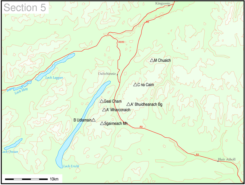
All 7 hills in these group can be climbed using public transport to reach the area.
Using Dalwhinnie as a starting point
It is possible to climb all the Drumochter Hills from Dalwhinnie and with its excellent transport links It should be possible to climb all these hills as "day walks" from further south if desired.
Trains from the south arrive at Dalwhinnie at 0916, 1225, 1601 and 2158 and depart at 1030, 1553, 1958 and 2128 (Monday to Saturday). Sunday trains arrive at 1159, 1618 and 2020 with departures at 1346 and 1939.
The first bus from the south (M91 Edinburgh to Inverness with Glasgow connection at Perth) arrives daily at Dalwhinnie road end layby at 1159, 1359, 1559, 1759 and 2009 with a returns at 938, 1138, 1338, 1548 and 1838.
For those approaching from the Inverness direction simply reverse the arrival and departure times from the south.
For those wishing to stay overnight the Dalwhinnie Inn would seem a relatively reasonably priced hostelry and would allow a more leisured climbing of the hills especially the group of four two the south.
For those "fortunate" enough to live in the London area or within reach of Crewe or Preston another possibility is to use the Inverness sleeper, which stops at Dalwhinnie at 0657 every morning except Sunday. Southbound services depart 2204 Monday to Friday evening and 2144 on Sundays.
Sgairneach
Mhor 991
m ![]() , Beinn
Udlamain 1011 m
, Beinn
Udlamain 1011 m ![]() , A'
Mharconaich 975
m
, A'
Mharconaich 975
m ![]()
![]()
The start for these hills is shown in both the SMC book and the Cicerone "Walking the Munros" as Balsporran Cottages. To reach this point start from Dalwhinnie and walk the 6kms south along the old military road that parallels the A9. There is an under-bridge at Balsporran beneath the main railway. and there appears to be another underpass a further 4km south giving access to Coire Domhain. Needless to say the railway itself should not be crossed illegally - trains are actually permitted to travel at 100 mph on this section.
A'Bhuidheanach
Bheag 936
metres ![]() and Carn na Caim 941 metres
and Carn na Caim 941 metres ![]()
These two hills have excellent access almost direct from Dalwhinnie village and can easily be climbed by using either the train or bus in a day.
Meall
Chuaich 951
metres ![]()
Access
to this hill starts by a walk of about 3km north from Dalwhinnie either along
the old A9 to Cuaich or by following the tracks along the aqueduct from the weir
over the River Truim in Dalwhinnie. Once again this is an obvious "day
walk"
The three hills A'Bhuidheanach Bheag, Carn na Caim and Meall Chuaich can also be combined into one longer walk as described below:
Section 6 The West Mounth: Blair Atholl to Braemar
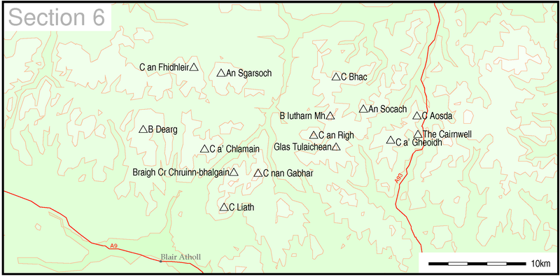
7 out of 15 hills can be climbed using public transport to reach the area.
Another 6 can be reached with long "walks in" so have been included.
Beinn
Dearg (1008m) ![]()
The walk starts less than 1km from Blair Atholl station.
Carn
a'Chlamain ![]()
The walk starts less than 1km from Blair Atholl station.
|
This hill climbed using public transport but before I started taking photographs for this website |
Beinn a' Ghlo with its three Munros
Carn
nanGabhar (1121m) ![]() Braigh Coire Chruinn-bhalgain (1070m)
Braigh Coire Chruinn-bhalgain (1070m)
![]() Carn Liath (975m)
Carn Liath (975m) ![]()
The start of the walk at Loch Moraig is roughly 5km from Blair Atholl along country lanes.
An
Sgarsoch (1006m) ![]() and Carn an Fhidhleir (994m)
and Carn an Fhidhleir (994m)
![]()
No public transport available
Bases for walks It has to be said that this area is not the most public transport friendly one for walkers but there are still possibilities for those to practice the "long walk in" The next series of hills are to be found around Spittal of Glenshee and Braemar. Those using public transport may find they need to stay in the area as links are often poor and mainly from the north east. Spittal of Glenshee There are limited public transport options to Spittal of Glenshee but it should be possible to climb these hills by staying here overnight - hotel and bunkhouse. Stagecoach service 71 now operates on Wednesdays and Saturdays from Blairgowrie to Spittal of Glenshee. Buses depart Blairgowrie at 0915 and 1725 (Wednesdays) returning at 1000 and 1830. On Saturdays there are four buses at 0855, 1155, 1455, 1715 (Nov to March) or 1855 (April to October). Returns on Saturdays from Spittal are at 0940, 1300, 1600, 1820 (Nov-March) or 2000 (April to October). Sadly the Heather Hopper service 502/3 service which gave some access to some of the hills has been axed in 2010 due to poor patronage. Braemar Stagecoach's services 201 and 202 link Aberdeen with Braemar ,taking just over 2 hours and with between 5 and 9 buses a day, is a useful service for walkers.
|
Glas
Tulaichean (1051m) ![]() and Carn an Righ (1029m)
and Carn an Righ (1029m) ![]()
The SMC book suggest these hills can be approached from Dalmunzie - this is a 2km walk from Spittal of Glenshee. With this extra distance the walk would probably take about 8 hours.
Beinn
lutharn Mhor (1045m)
![]() and Carn Bhac (946m)
and Carn Bhac (946m)
![]()
If you're prepared to walk about the 14km there and back from Braemar along the C class road and forest trails it is possible to reach the starting point for this walk at Inverey. This would probably add about 3 hours to the 9 hours of the actual walk from Invervey.....
Another option would be to climb these hills on separate days, thus shortening the time at the expense of a repeat visit.
An
Socach (944m)![]()
The start of this walk is about 8km from Braemar up Glen Clunie. Given that the walk from Braemar will add about 3-4 hours and the climb from Baddoch is about another 4 hours so this hill is clearly a possibility. Most of the road walking can be along the C class road with the rest on the verges of the A93
The
Cairnwell (933m), ![]() Carn Aosda (917m)
Carn Aosda (917m) ![]() and Carn a' Gheoidh (975m)
and Carn a' Gheoidh (975m) ![]()
It should be possible to climb these three hills in a fairly long day from Spittal of Glenshee by walking by the A93 for about 4km to Rhiedorrach and then taking to the hills.
Alternatively there's also the walk in from Braemar to Baddoch (as for An Socach). From there climb carn Aosda, the Cairnwell and Carn a'Gheoidh before dropping down back to the Baddock Burn. The main walk will be about 6-7 hours plus the road and lane walking of 3-4 hours.
Section 7 The East Mounth: Glen Shee to Mount Keen
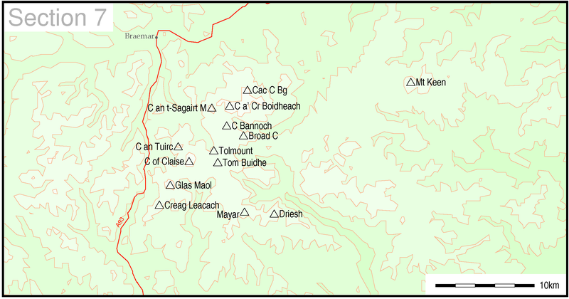
6 out of 14 hills can be climbed using public transport to reach the area.
|
For most walkers dependant on public transport Braemar is the obvious base if visiting this area. Some of the hills might be best climbed from Spittal of Glenshee. See Section 6 above for transport details. |
Glas
Maol (1068m) ![]() and Creag Leacach (987m)
and Creag Leacach (987m) ![]()
There are several possible ways of climbing these hills. The first is to be based at Spittal of Glenshee and walk by the A93 for 6km to near the Devil's Elbow and then follow the SMC's route. However, this does not strike me as a particularly safe routeas much of the road is fenced, so I've excluded them.
Carn
an Tuirc (1019m) ![]() , Cairn of Claise
(1064m)
, Cairn of Claise
(1064m) ![]() , Tolmount (958m)
, Tolmount (958m)
![]() and Tom Buidhe (957m)
and Tom Buidhe (957m)
![]()
Now the Heather Hopper does not run the only option is to walk from Braemar and do the walk in the opposite order starting with Carn an Tuirc then Cairn of Claise, Tom Buidhe and finishing with Tolmount. Then drop down to Jock's Road and the return via the lodge to Braemar. This would be an extremely long day and only practical for really strong walkers so I've not included these Munros as possible without a car.
Carn
an t-Sagairt Mor (1047m) ![]() , Carn a' Choire Bhoidheach (1110m)
, Carn a' Choire Bhoidheach (1110m)
![]() and Lochnagar
(1155m)
and Lochnagar
(1155m) ![]()
The SMC book suggests that the first two hills should be climbed starting at Auchallater (a 3km walk from Braemar along the side of the A93). The time to reach Carn a' Choire Bhoideach from Braemar will be about 5 hours.
However, Lochnagar is a mere 3km and a further 100m of ascent beyond Carn a' Choire Bhoideach so Lochnagar is certainly within walking distance of Braemar although, inevitably, quite a long day of about 9-10 hours. Sadly walkers from Braemar aren't going to see the magnificent corrie that can be seen from the approach from Spittal of Glenmuick.
The return to Braemar would be along the track to Lochcallater Lodge, avoiding climbing to the summits of the two peaks already climbed on the way out.
Cairn
Bannoch (1012m)![]() and Broad Cairn (998m)
and Broad Cairn (998m)
![]()
These are another two hills that the SMC book suggests should be climbed from Spittal of Glenmuick. However, they can be reached easily from Auchallater by following the track used to reach Carn an t-Sagairt Mor and then heading off south east to Cairn Bannoch and Broad Cairn. No doubt, strong walkers might even combine these two hills with the Lochnagar walk above!
Driesh
(947m) ![]() and Mayar (928m)
and Mayar (928m)
![]()
No public transport available.
Mount
Keen (939m) ![]()
The starting point for this hill using public transport is Ballater.
Ballater is well served by buses from Aberdeen - at least hourly on weekdays and two hourly for most of Sunday. There are also buses to Braemar (between 5 and 9 depending on day of the week).
Starting at Bridge of Muick, about 1km from Ballater centre tracks lead all the way to the Mounth Road and the summit a distance of about 12km.
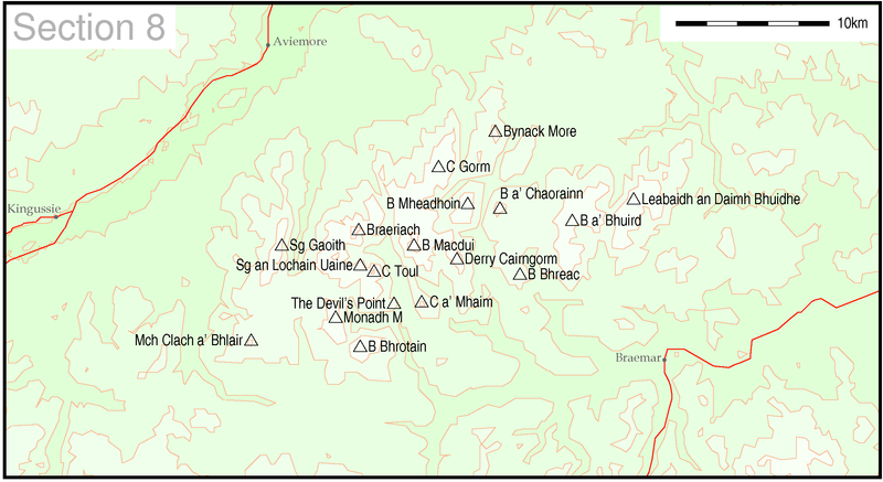
10 out of 18 hills can be reached using public transport to get to the start of the walk.
It has to be said that the Cairngorms are a difficult group of hills to climb using public transport (and, of course, often difficult even with a car), but a good proportion can be reached. Braemar, Colyumbridge, Glenmore and Aviemore are the obvious bases for walkers.
|
Stagecoach's services 201 and 202 link Aberdeen with Braemar ,taking just over 2 hours and with between 5 and 9 buses a day. |
Beinn
a' Bhuird (1197m) ![]()
The Braemar to Aberdeen bus passes one of the suggested starting points for this hill at Invercauld Bridge . The SMC book suggests a time of 4h 40m to reach the summit from Invercauld.
Ben
Avon (1171m) ![]()
Use the Braemar to Aberdeen bus to reach Invercauld Bridge. The SMC book suggests a time of 5h to reach the summit from Invercauld.
Beinn
Bhreac (931m) ![]() and Beinn a'Chaorainn (1083m)
and Beinn a'Chaorainn (1083m) ![]()
No public transport available.
Carn
a' Mhaim (1037m) ![]() and
Derry Cairngorm (1155m)
and
Derry Cairngorm (1155m) ![]()
No public transport available.
|
Fortunately, the bus service from Aviemore to the Cairngorm car park has improved tremendously in recent years. When we climbed these hills about five years ago we had to hire a car to allow us to do the walks. Today the service 34 from Grantown and Aviemore operates hourly for most of the day with a really useful evening bus for those long summer days. Aviemore departures are at 07.21 (schooldays) and 07.56 (daily except schooldays). Then the service is hourly from 09.16. Services operate more or less the same seven days a week. Sunday services run from the start of June to end September and then January to April. From Cairngorm the return buses are at 40 minutes past the hour until 16.40 (no bus at 15.40 on school days). In the summer there are later buses at 17.40 and 20.08 (19.25 on Sundays)
|
Cairngorm
(1244m) ![]() and Ben Macdui (1309m)
and Ben Macdui (1309m) ![]()
I've grouped these two hills together. From the Cairngorm Coire Cas car park the SMC book gives a time of 1h 40m to Cairngorm and 3h 40m to Ben Macdui. A return time of about 2h 30m should give a good day's walk between buses.
Beinn
Mheadhoin (1182m) ![]()
This hill could also be combined with Cairngorm although probably not with Ben Macdui, unless you are a really strong walker. The SMC book suggests 3h 40m from the car park. The return walk would probably not be a lot shorter as you have to climb back onto the Cairngorm plateau to return to the bus.
Bynack
More (1090m) ![]()
This is another hill that we climbed before the bus service improved. Leave the bus at Glenmore and walk past Glenmore Lodge in about 3h 30m to 4h.
Braeriach
(1296m) ![]()
For those of you who are happy to cross the boulder field in the Chalamain Gap once again the bus to Cairngorm gets you within 4h walk of the summit.
Personally, having tried to cross this leg breaking section of the walk, I'd opt for the approach from Colyumbridge. The Cairngorm bus passes through here. The walk from Colyumbridge is about 5h 30m so with a return of about 4h it should be possible to complete the walk between the first morning bus and one of the evening ones. If there's no convenient service back it's only 3km back to Aviemore along the road.
Cairn
Toul (1291m) ![]() and
Sgor
an Lochaine Uaine (1258m)
and
Sgor
an Lochaine Uaine (1258m) ![]()
By combining these two summits with Braeriach it is possible to do this in a very long day from Colyumbridge. I used a taxi from Aviemore to start the walk at Whitewells and finished at Colyumbridge just in time for the last bus, although I actually ordered a taxi. It gave a very long day of about twelve hours walking.
The
Devil's Point (1004m) ![]()
It might be possible to reach this hill by a strong walker using the same route as for Cairn Toul and then returning by dropping down into the Lairig Ghru on the return. However, except for really strong walkers this is probably not a realistic option.
Monadh
Mor (1113m) ![]()
Beinn
Bhrotain (1157m) ![]()
Mullach
Clach a' Bhlair (1019m) ![]()
No public transport options.
Sgor
Gaoith (1118m) ![]()
A possible approach to this hill is from Colyumbridge so the Cairngorm bus can be used to reach the starting point. Follow the track through the forest en route to Loch Einich. Just before the track crosses the river near the Allt Ruigh na Sroine strike off up the hillside to Creag Dubh. Then follow the generally rising rising ridge southwards over Sgoran Dubh Mor to Sgor Gaoith. It's a long, roughly 28km round trip, but practical route in the time between the early morning bus from Aviemore and one of the evening buses back.
Section 9 Glen Roy to the Monadhliath

6 out of 9 hills can be reached using public transport to get to the start of the walk.
Geal
Charn (926m) ![]()
No public transport options
Carn
Dearg (945m) ![]() , A' Chailleach (930m)
, A' Chailleach (930m) ![]() and Carn Sgulain (920m)
and Carn Sgulain (920m)![]()
The SMC book suggests you start the walk 2km from Newtonmore at the end of the public road in Glen Blanchor. They can either be walked as two separate trips or as one longer 24km round.
In the winter 2009 timetable the first train arrival at Newtonmore from the south is at 09.26 from Glasgow.
Southbound trains are at 17.52, 19.46 and 21.17 to Glasgow/ Edinburgh
The first Citylink Edinburgh to Inverness bus does not arrive until 1214 and the every two hours until 1814.
Southbound buses are at 1533 and 1823.
The sleeping car train from London, Crewe and Preston arrives at 0709 Monday to Saturday and leaves at 2149 Monday to Friday and 2129 Sundays.
Creag
Meagaidh (1128m) ![]()
For those prepared for a longish walk in to the start of the SMC guide's suggested route there is either a 7km trek along the A86 from Tulloch station or a longer (and probably more pleasant) 10km walk over the Laggan dam and through forests along the southern side of the reservoir crossing over the River Spean at Torgulbin . The starting point at Moy is 1km west on the A86.
The time for the climb to the summit from Moy is 2h 50m so a return should be possible within 4h 30m. The return walk in from Tulloch would be another 3 to 4 hours so it is clearly a feasible walk using the train.
Trains from the south to Tulloch arrive at 0917 (the sleeper from London) with seated accommodation from Edinburgh and Glasgow (change at Westerton) or the later train from Glasgow at 1135. Southbound trains leave at 1808 and 2030 (the sleeper) to Westerton (Glasgow connection) and Edinburgh. This option is available Monday to Saturdays BUT the southbound sleeper option does not run on Saturday nights.
Sunday services from the south do not allow this walk to be done.
If coming from Fort William trains arrive at 0813 and 1211 with returns at 1536 and 2135 (daily except Sundays).
On Sundays in the summer timetable (from end May) the first arrival is at 1214 with a northbound at 2135.
Carn
Liath (1006m) ![]() and Stob Poite Coire Ardair (1054m)
and Stob Poite Coire Ardair (1054m)
![]()
No public transport options for mere mortals!
However, strong walkers might feel able to extend the Creag Meagaidh walk to one or both of these summits but a close eye would need to be kept on the time given the need to return by the same route. Possibly staying at the Tulloch station bunkhouse would help.
Beinn
a' Chaorainn (1052m) ![]() and Beinn Teallach (915m)
and Beinn Teallach (915m)
![]()
The starting point for these two hills is at Roughburn roughly 2km east along the A86 from Tulloch station on the West Highland Line. The circular walk from Roughburn takes about 7 hours with another hour needed for the return road walk.
Trains from the south to Tulloch arrive at 0917 (the sleeper from London) with seated accommodation from Edinburgh and Glasgow (change at Westerton) or the later train from Glasgow at 1135. Southbound trains leave at 1808 and 2030 (the sleeper) to Westerton (Glasgow connection) and Edinburgh. This option is available Monday to Saturdays BUT the southbound sleeper option does not run on Saturday nights.
Sunday services from the south do not allow this walk to be done.
If coming from Fort William trains arrive at 0813 and 1211 with returns at 1536 and 2135 (daily except Sundays).
On Sundays in the summer timetable (from end May) the first arrival is at 1214 with a northbound at 2135.
18 hills out of 26 are possible by public transport (plus one extra for the adventurous)
It goes without saying that it's probably best to stay in the area to attempt to climb these hills if you're using public transport. It is just about possible to climb a few of these hills if you are based in Fort William but I'd be more inclined to find accommodation at Glenfinnan, the Cluanie Inn in Glen Shiel or at Shiel Bridge. Public transport does allow you to reach these areas quite easily.
Gulvain
(987m) ![]()
Shiel Bus service 500 leaving Fort William at 0855 will drop you off at Drumsaille at 0918. There's a return at 1640 on school days and 1622 non schooldays. There's a later bus towards Glenfinnan at 1803. This would suggest the option of staying overnight at Fort William on the first night and then moving on to Glenfinnan ready to climb the next two hills in this section. The car-less Munroists has to think "outside the box"!
If you're prepared to walk along the A830 road for 4km you could take the train to Locheilside station. Google Streetview shows wide verges so this should be safe. The 0830 (Monday to Saturday) from Fort William arrives at 0852 with a return at 1911.
Alternatively it's possible to catch the bus one way and take the train back. Yet another option would be to take the morning bus and then the 1803 bus to Glenfinnan (arrives 1810) and return to Fort William on on the 1903 train. This would avoid any road walking. (Monday to Fridays only)
By staying in Glenfinnan you can get the bus to 0815 bus to Drumsaille - the junction of the A830 and A861and then the 1803 bus back in the evening.
Sgurr
Thuilm (963m) ![]() and Sgurr nan Coireachan (956m)
and Sgurr nan Coireachan (956m)
![]()
These two hills can easily be reached from Fort William on the train arriving at Glenfinnan at 0903 and returning on the 1903 to Fort William.
Sron
a' Choire Ghairbh (937m) ![]() and Meall na Teanga (918m)
and Meall na Teanga (918m)
![]()
These two hills are yet another pair that can be easily tackled by public transport. The Citylink Glasgow to Skye and West Coast Motors/ Stagecoach Highland Fort William to Inveness buses pass Laggan Locks nine times a day (Monday to Saturday) and 5 times a day on Sundays. Departures from Fort William are at 0730, 0845 and 1030 with a journey time of about 30 minutes. Returns from Laggan Locks are at 1432, 1647 and 1852. On Sundays departure from Fort William is at 1015 and the return is at 1852.
It would even be possible to climb these hills travelling to and from Glasgow for the day (Monday to Saturday only). The 0700 from Glasgow arrives at Laggan at 1100. There is a return bus at 1648 changing at Fort William connecting into the train to Glasgow at 1737 or the coach at 1910. In theory there is a later return possible at 1845 from Laggan to Inverness but I'd view the ten minute connection into the last train from Inverness to Glasgow with suspicion!! Unless you are a really strong and fast walker you'd probably have to climb these two hills on separate occasions.
Another possibility for the public transport conscious walker is to stay at the Great Glen Hostel which is on the A82 just before the locks.
Warning:
Whilst Laggan Locks has a bus shelter and layby for buses heading east or north, on the westbound side of the road there is neither. To make matters worse it's on a sharp curve. I was told to stand as obviously as possible near the bend and put my hand out. The driver was clearly not too happy about having to stop in what he thought wasn't a safe place and suggested I should have stood on the opposite side of the road by the shelter. That wouldn't be much use if you are hidden by traffic!! The photo below taken from Google Streetview shows the situation looking east.
Gairich
(919m) ![]()
Sgurr Mor
(1003m) ![]()
Sgurr nan
Coireachan (953m) ![]()
Garbh Choich
Mhor (1040m) ![]()
Sgurr na
Ciche (1040m) ![]()
No public transport options for the above hills.
Beinn
Sgritheall (974m) ![]()
This hill is climbed from Arnisdale which has one daily bus service. Leave Glasgow at 07.00 or Fort William at 10.15 on the Uig bus. The connection is made at Inverinate Ault Na Chruinn (opposite the restaurant) arr 11.44 dep 11.52 arriving Arnisdale at 13.08. The climb and descent should take about 3h 30m. Accommodation will have to be arranged at Arnisdale or at the Glenelg Inn. The later would entail a 14km walk along the road - probably about 2h 30m to 3 hours.
The return bus leaves Arnisdale at 07.52 and Glenelg at 08.25. Change at Inverinate arr 09.08 dep 09.33 to arrive in Fort william at 11.00.
Meall Buidhe
(946m) ![]()
Luinne Bheinn
(939m) ![]()
No public transport options for the above hills.
Ladhar Bheinn
(1020m) ![]()
Take the 0821 Mallaig train
from Glasgow and then the Bruce Watt ferry to Inverie, arriving at 1500. This
link is available Mon/ Tues/ Fri all year and Monday to Friday from mid-May to
mid-September. The return journey leaves at 1100 and arrives in Glasgow at 2129
(after a four hour wait in Mallaig!!) or at 1600 arriving at 0020 (change at
Fort William into the sleeper and then Westerton for Glasgow).
This is a really great way of reaching Knoydart. I used the ferry a few years
ago and thoroughly enjoyed the all too brief remoteness. Accommodation is
available in Inverie. Click below to go to the Bruce Watt ferry page.
http://www.knoydart-ferry.co.uk/inverie-knoydart.html
Gleouraich
(1035m) ![]() and
Spidena
Mialach (996m)
and
Spidena
Mialach (996m)![]()
These hills can be climbed
from the Cluanie Inn by taking the track used to reach the South Glen Shiel
ridge walk to about 103073 and then crossing the River Loyne at a point marked
as Ford to climb Spidean Milach and then Gleoraich.
Sgurr a'
Mhaoraich (1027m) ![]()
No normal public transport.
However, for those with a real sense of adventure this hill can be reached using public transport!!
Leave Glasgow at 07.00 or Fort William at 10.15 on the Uig bus. The connection to Arnisdale is made at Inverinate Ault Na Chruinn (opposite the restaurant) arr 11.44 dep 11.52 arriving Arnisdale at 13.08. From here take the ferry, which needs to be pre-booked to Kinloch Hourn or the Barrisdale bothy .
The hill can be climbed from 1km south of Kinloch Hourn and takes about 5 hours
Clearly accommodation will need to be in advance in Kinloch Hourn or Barrisdale (from Barrisdale to Kinloch Hourn is roughly 8km for the round walk)
For the return back to Arnisdale an early start will need to be requested as the bus back to Inverinate leaves at 07.52.
South Glen Shiel Ridge hills
Creag a'Mhaim
![]() ,
Druim Shionnach
,
Druim Shionnach ![]() , Aonach Air Chrith
, Aonach Air Chrith ![]() , and
Maol
Chinn-Dearg
, and
Maol
Chinn-Dearg ![]()
Sgurr an Doire Leathain ![]() , Sgurr an
Lochain
, Sgurr an
Lochain ![]() and Creag nan Damh
and Creag nan Damh ![]()
Citylink coaches from Glasgow and Inverness to Skye stop at the Cluanie Inn and, combined with a stay at the inn, make this ridge feasible for walking without a car.
This walk, as stated numerous times, is difficult to complete without return transport. Some writers have suggested that the buses will stop at the layby in Glen Shiel near the 1719 battlefield sign. Whether you are prepared to risk this is another matter!! If it does stop there's a useful service that leaves Shiel Bridge at 1859 which gets back to Cluanie Inn at 1918. An early start from the inn (say 0830) should see you at the battlefield by 1730 to 1800.
Does anybody have experience of using the bus in this area?
Another alternative would be to use the "taxi" service the hotel offers to vistors and ask to be taken down the glen to the battlefield and then walk back along the ridge to the inn.
The Saddle
(1010m) ![]() and Sgurr na Sgine (946m)
and Sgurr na Sgine (946m) ![]()
My preferred option for climbing these hills would be to travel to and stay at Shiel Bridge (campsite or Kintail Lodge Hotel) to climb these hills there are two alternative approaches. The first means a 6km walk along the verges of the A87 to near Achnangart farm. There is a bus at 0934 from Shiel Bridge which might stop at the farm for you but, frankly, you might as well set off earlier and walk.
A more appealing approach is probably up the valley of the Allt Undalain and then by the Allt a' Choire Chaoil to join the Forcan Ridge (perhaps avoiding this exposed ridge by taking the alternative suggested in the SMC book).

22 hills out of 22 are possible by public transport (this includes six where you walk in to Glen Affric hostel from near the Cluanie Inn)
To walk many of these hills without a car is a challenge although, of course, even with private transport some of them require a long walk in to the start.
There would appear to be six centres that will help the public transport Munroist achieve his aims.
Ross's Minibuses provide a three days a week service from Inverness Bus station at 08.45 which arrives Cannich at 10.10 and then goes to the Glen Affric car park arriving 10.40 . The bus then makes two round trips to Cannich before returning to Inverness from Glen Affric car park at 1700 arriving back in Inverness at 1845. (Mon/ Wed/ Fri from 6th July to 11 September 2009) There are also other buses as far as Cannich on Tuesdays and Fridays from Dingwall, Muir of Ord or Inverness. |
Toll Creagach (1054m) ![]() and Tom
a' Choinich (1112m)
and Tom
a' Choinich (1112m) ![]()
Using the Glen Affric bus it should be possible to climb these hills in the 6 hours or so between buses, although doing both of them in the same day might be too much. Of course if you miss the bus you've got a 15km walk back to Cannich.......
Mam Sodhail (1181m) ![]() , Carn
Eighe (1183 m)
, Carn
Eighe (1183 m) ![]() and Beinn Fhionnlaidh (1005m)
and Beinn Fhionnlaidh (1005m)
![]()
Base yourself at the Glen Affric hostel, after walking in from the Cluanie Inn would allow the hills to be climbed. Remember though that you'll also need to carry your food and a sleeping bag to this hostel.
An Socach (921m) ![]()
Again the only practical approach for this hill is by walking from the Cluanie Inn to the Glen Affric hostel. It might be possible to walk it in a long day from the Cluanie Inn - there's a roughly 20km round walk from the inn to the hostel and then another 6km there and back to the summit.
Sgurr nan Ceathreamhnan (1151m)
![]() and Mullach na Dheiragain (982m)
and Mullach na Dheiragain (982m) ![]()
These pair of hills are another best approached from the Glen Affric hostel.
Beinn Fhada (1032m) ![]() and A'
Ghlas-bheinn (918m)
and A'
Ghlas-bheinn (918m) ![]()
The start of this walk at Morvich is about 4km from Shiel Bridge - a short section along the main road and then on lanes.
Carn Ghluasaid (957m),
![]() Sgurr nan Conbhairean (1109m)
Sgurr nan Conbhairean (1109m) ![]() and Sail Chaorainn (1002m)
and Sail Chaorainn (1002m) ![]()
The start of the walk is about 5km east of the Cluanie Inn on the A87.
A' Chralaig (1120m) ![]() and Mullach
Fraoch-choire (1102m)
and Mullach
Fraoch-choire (1102m)![]()
For a change this walk starts almost at the door of the Cluanie Inn - well about 2km east!
Ciste Dhubh (979m) ![]()
Another walk that starts just east of the Cluanie Inn.
Aonach Meadhoin (1001m),
![]() Sgurr a' Bhealaich Dheirg (1036m)
Sgurr a' Bhealaich Dheirg (1036m) ![]() and Saileag (956m)
and Saileag (956m) ![]()
The start and end points for these hills lie about 2km and 7km west of the Cluanie Inn. If you feel lazy the hotel "taxi" service will no doubt take you to the furthest point near Saileag but frankly it hardly seems worth it.
Sgurr na Ciste
Duibhe (1027m)![]() , Sgurr Na Carnach (1002m)
, Sgurr Na Carnach (1002m) ![]() ,
Sgurr Fhuaran (1067m)
,
Sgurr Fhuaran (1067m) ![]() and the Five Sisters of Kintail
and the Five Sisters of Kintail
After some consideration the most logical way to tackle these hills is to use the Cluanie Inn's "taxi" service to take you to the starting point of the walk at one of the car parks in Glen Shiel and then walk to the end near Shiel Bridge. There's a bus back to Cluanie at 1859 or, to save the worry of having to rush for the bus, you could stay at Shiel Bridge.
Section 12 Glen Cannich to Glen Carron
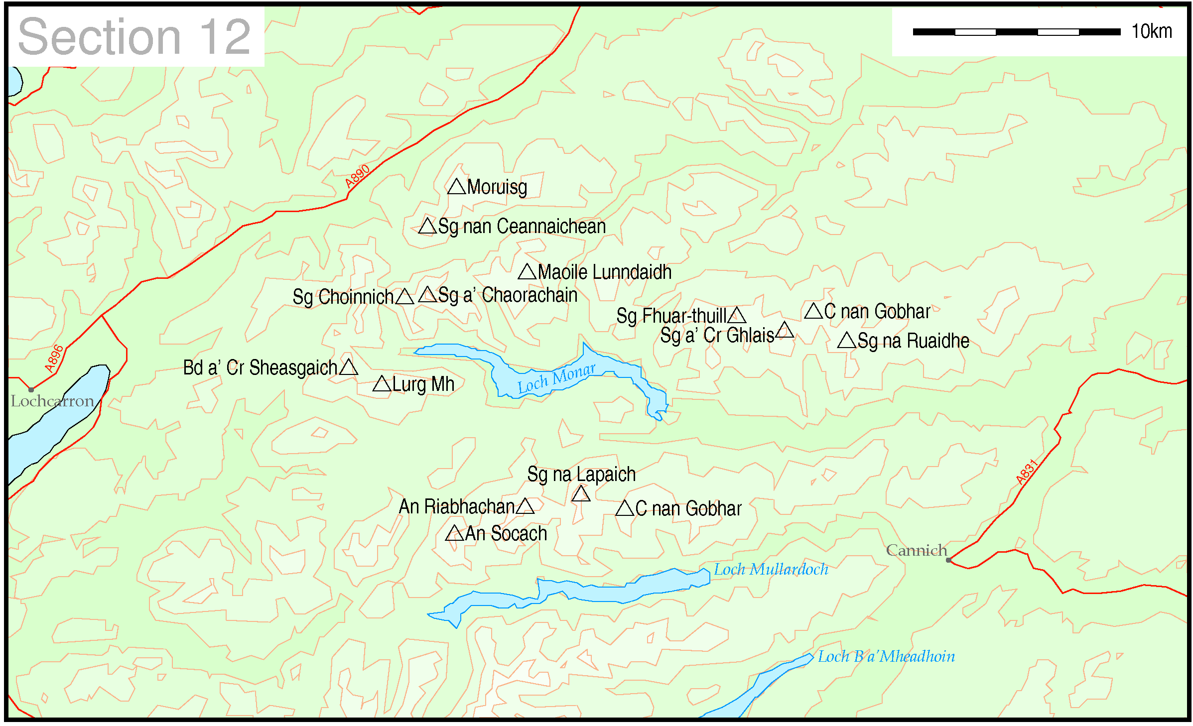
6 hills out of 13 are possible by public transport
An Socach (1069m) ![]()
Not to be confused with the other An Socach in section 11 this much higher hill has no public transport options available.
An
Riabhachan (1129m) ![]() , Sgurr na Lapaich (1150m)
, Sgurr na Lapaich (1150m)
![]() and Carn nan Gobhar (992m)
and Carn nan Gobhar (992m)
No public transport options.
Sgurr
na Ruaidhe (993m) ![]() , Carn nan Gobhar
(992m)
, Carn nan Gobhar
(992m)![]() , Sgurr a' Choire Ghlais (1083m)
, Sgurr a' Choire Ghlais (1083m)
![]() and
Sgurr Fuar-thuill (1049m)
and
Sgurr Fuar-thuill (1049m) ![]()
No public transport options
Bidein
a' Choire Sheasgaich (945m) ![]() and Lurg Mhor (986m)
and Lurg Mhor (986m)
![]()
Sgurr
a' Chaorachin (1053m) ![]() and Sgurr Choinnich (999m)
and Sgurr Choinnich (999m)
![]()
Moruisg
(928m) ![]() and Sgurr nan Ceannaichean (915m)
and Sgurr nan Ceannaichean (915m)
(note: Sgurr nan Ceannaichean is no longer a Munro but I've kept it on this list as it's a Corbett and might as well still be climbed if you are here!!)
Maoile
Lunndaidh (1007m) ![]()
The SMC guide starts all four of these walks at Craig, 4km west of Achnashellach station on the Inverness to Kyle of Lochalsh line. The first train from Inverness arrives at 1036 and the evening train returns at 1805. Please note that this is a request stop so the conductor must be told on the outward journey and you have to stick out your hand to tell the driver to stop on the return.
Completing the walks as in the SMC guide in the time available between these two trains might be a little tight.
However, Gerry's Achnashellach Hostel at Craig does give you the option of a less hurried day and a return on a train another day.
Trains from Inverness arrive at Achnashellach at 10.36, 1234, (1506 summer only) and 1935
Departures are 07.11, 12.54 (15.29 summer only) and 18.05.
On Sundays there is only one service; arrival from Inverness at 12.48, (19.36 in summer only) and departures at (12.11 summer only) and 1612.
A further option would be to stay at Strathcarron. This would allow you to arrive at Strathcarron at 07.11 and return at 19.35
PLEASE BE AWARE THAT ONE SERVICE IN EACH DIRECTION DOES NOT CALL AT ACHNASHELLACH
Section 13 Cuillin and Torridon
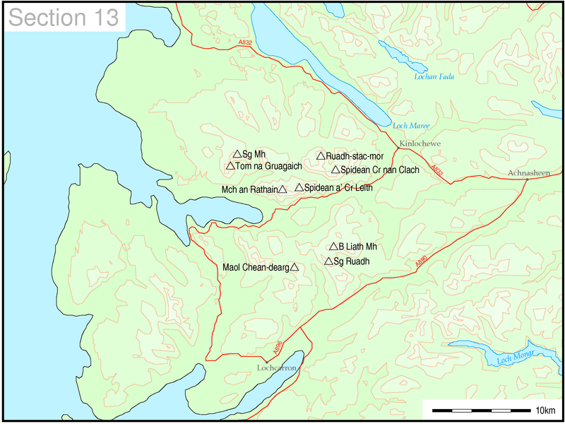
All 9 hills can be accessed by using public transport.
Maol Chean-dearg (933m) ![]()
Strathcarron or Achnashellach stations on the Inverness to Kyle of Lochalsh line provide the starting point for this hill. The SMC book's walk starts from Coulags, which is about 5km from either station on the A890.
The time available between morning and evening trains is a little tight so it might be best to stay at Gerry's Achnashellach Hostel or the Strathcarron Hotel.
Beinn
Liath Mhor (926m)![]() and Sgorr Ruadh (962m)
and Sgorr Ruadh (962m) ![]()
Once again the time available between morning and evening trains is a little tight so it might be best to stay at Gerry's Achnashellach Hostel.
A further option would be to stay at Strathcarron. This would allow you to arrive at Strathcarron at 07.11 and return at 19.35
Torridon area
Bus services in Torridon have been affected by the withdrawal of the Post buses. There are, supposedly, moves afoot to find a replacement.
|
To reach Torridon the connection is now: Inverness station dep 09.00 (train) Strathcarron arr 10.46 Strathcarron dep 12.45 (bus) Torridon arr 13.45 |
| The return journeys are:
Torridon dep 07.45 Kinlochewe arr 08.05 Kinlochewe dep 10.05 Dingwall arr 11.05 (all by bus)
or Torridon dep 09.45 Lochcarron arr 10.20 Lochcarron dep 12.15 Strathcarron arr 12.25 Strathcarron dep 12.49 (train) Inverness arr 14.39 |
It is presumed that visitors to the area will be staying at the SYHA hostel in Torridon.
Beinn
Alligin - Sgurr Mhor (986m) ![]() and Torn na Gruagaich (922m)
and Torn na Gruagaich (922m)
![]()
The start of this walk is 4km west along the loch-side road from the hostel.
Liathach
- Spidean a' Choire Leith (1055m) ![]() and Mullach an Rathain (1023m)
and Mullach an Rathain (1023m)
![]()
The start of this walk is 4km east along the A 896 from the hostel.
Beinn Eighe -
Ruadh-stac Mor (1010m) ![]() and Spidean Coire nan Clach (993m)
and Spidean Coire nan Clach (993m)
![]()
The start of this walk is 6km east along the A 896 from the hostel.
Section 14 Loch Maree to Loch Broom
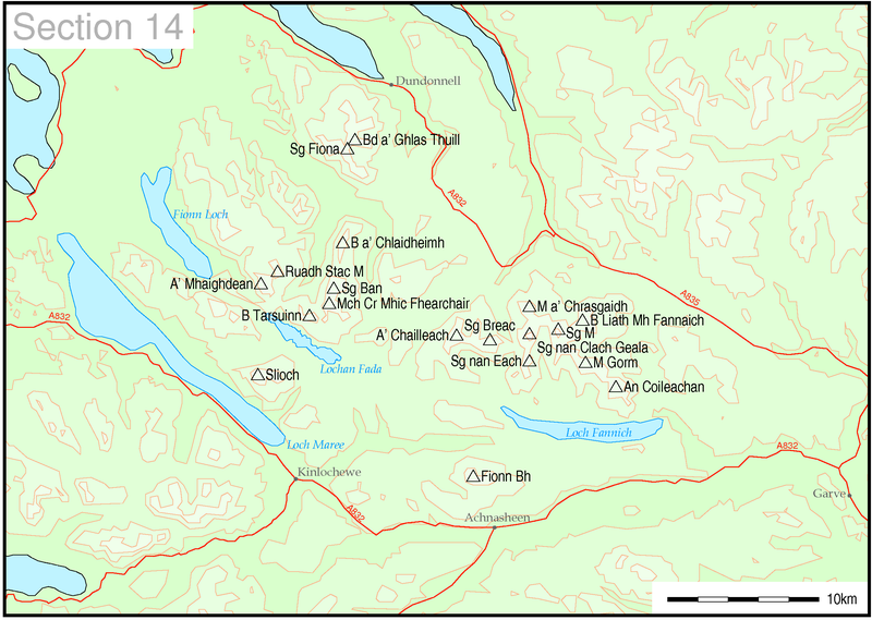
18 out of 19 hills can be climbed using public transport.
Slioch
(981m) ![]()
The SMC book suggests the walk starts from Incheril on the edge of Kinlochewe. Accomodation will be needed to be booked in Kinlochewe.
Westerbus service N80 operates Monday to Friday from Inverness direct to Kinlochewe at 17.20 arriving at 18.55. In the return direction the bus leaves Kinlochewe at 08.55 arriving Inverness at 10.25.
Note: Traveline also gives another possibility but these involve journeys considerably longer and, no doubt, more expensive as well.
A'
Mhaighdean (967m) ![]()
Ruadh
Stac Mor (918m) ![]()
These two hills can be climbed from Poolewe. Accommodation will need to be booked in Poolewe.
Westerbus service N80 operates Monday to Friday from Inverness direct to Kinlochewe at 17.20 arriving at 19.45. In the return direction the bus leaves Kinlochewe at 08.05 arriving Inverness at 10.25.
Note: Traveline also gives another possibility but these involve journeys considerably longer and, no doubt, more expensive as well.
Beinn
Tarsuinn (937m) ![]()
Mullach
Coire Mhic Fhearchair (1018m) ![]()
Sgurr
Ban (989m) ![]()
The SMC book suggests that one approach to these hills should from Incheril on the edge of Kinlochewe. Accommodation will be needed to be booked in Kinlochewe. The book does warn about the length of this route. The three hills are respectively 4h 40min, 5h 40 min and 6h 10min from Incheril.
Westerbus service N80 operates Monday to Friday from Inverness direct to Kinlochewe at 17.20 arriving at 18.55. In the return direction the bus leaves Kinlochewe at 08.55 arriving Inverness at 10.25.
Note: Traveline also gives another possibility but these involve journeys considerably longer and, no doubt, more expensive as well.
Beinn
a' Chlaidheimh (916m) ![]()
No public transport option
An
Teallach - Beinn a' Ghlas Thuill (1062m) ![]() and Sgurr Fiona (1060m)
and Sgurr Fiona (1060m) ![]()
These two hills can be climbed from the Dundonnell Hotel.
A direct bus operates on Mondays, Wednesdays and Saturdays from Gairloch to Inverness picking up at the Dundonnell Hotel at 0850 and arriving Inverness at 1025. The return from Inverness is at 1720 arriving at the hotel at 1900 - just in time for dinner!!
Meal
Gorm (949m) ![]() and An Coileachan (923m)
and An Coileachan (923m)
![]()
The starting point for this walk is the at the north west end of Loch Glascarnoch on the A835 about 7km from the Aultguish Inn. The first bus from Inverness arrives at 08.56. However, it might be possible to persuade the driver to drop you off at the start of the walk near the loch end.
If not an hour and a half's walk, along the verges of the unfenced A835, should see you at the start of the SMC guide's walk. From here it is three hours to the summit of An Coileachan and four to Meal Gorm. Unless you've got a cooperative driver you probably won't be able to be back at Aultguish in time for the evening bus back to Inverness at 17.13 (Mon-Fri) or 17.53 (Sat) so an overnight stay at Aultguish Inn seems likely.
Sgurr
Mor (1110m)
![]() and Beinn Liath Mhor Fannaich (954m)
and Beinn Liath Mhor Fannaich (954m) ![]()
The starting point for this walk is the at the the dam at Lochdrum on the A 835 about 10km from the Aultguish Inn. The first bus from Inverness arrives at 08.56. Ask the driver to drop you off near the cottages near the dam at the start of the walk. There's a car park on the south side of the road where the bus could pull up off the road.
From here it is four hours to the summit of Sgurr Mor and four and a half hours to Beinn Liath Mhor Fannaich and probably another hour and a half back to Lochdrum. At the end of the day you're faced with that 10km yomp down the main road - it's an unfenced road and Google Streetview shows that the verges are quite wide. About two hours should see you back at the Inn. Once again completion of the walk in time for the bus depends on the cooperation of the driver. Otherwise it's another overnight stay.
It's possible that the bus to Inverness would stop if you stood in a safe place, such as a layby but......
Meall
a'Chrasgaidh (934m) ![]() ,
Sgurr
nan Clach Geala (1093m)
,
Sgurr
nan Clach Geala (1093m) ![]() and
Sgurr
nan Each (923m)
and
Sgurr
nan Each (923m) ![]()
Sgurr
Breac (999m) ![]() and
A'Chailleach
(997m)
and
A'Chailleach
(997m) ![]()
My first reaction to using public transport to climb this group of hills was that it isn't possible. The nearest public transport is at Braemore Junction on the Inverness to Ullapool Citylink route. This stop lies 6km away from the SMC book's suggested starting point on the A832.
The morning bus from Inverness arrives at Braemore Junction at 09.11 and the return leaves at 1658, which gives about 7h 30 min for the walk, allowing a little leeway. The 12km road walk will need about 2h 30min which leaves about 5 hours for the hills. By tackling these hills in two or three expeditions it should be possible to bag them all.
If you prefer to stay in Ullapool the morning bus arrives at Braemore at 1008 and the return is at 1601 - a bit tight but probably possible provided the morning bus isn't delayed waiting for the ferry from Stornoway.
The thought of being stuck at Braemore Junction isn't appealing, but remember by pre-booking your ticket, the driver will know that he's expecting to pick you up, so the bus isn't likely to go sailing past! Just be at the stop 10 minutes or so before the bus is expected.
Another possibility would be to stay at the Dundonnell Hotel which is about 10km further along the road from the SMC starting point for these hills.
On the first day take the Citylink bus to Braemore Junction arriving at 09.11, walk to the starting point on the A832, climb some of the hills and then walk to Dundonnell. The next day take the Inverness bus from the hotel at 08.50 as far as the starting point for these hills (make sure that it's a Monday, Wednesday or Saturday). Then climb the rest of the hills and finally return to Braemore Junction in time for the Citylink bus to Inverness at 1753.
Fionn
Bheinn (933m) ![]()
This hill can be easily accessed by public transport without staying in the immediate area starting from Achnasheen station on the Kyle of Lochalsh line. The time for the walk is between 4h 30 min and 5 hours so can easily be climbed in between the arrival of the morning train from Inverness at 10.36 and the evening train at 18.05. In summer it should even be possible to catch the earlier 15.29 if needed.
Section 15 Loch Broom to Easter Ross
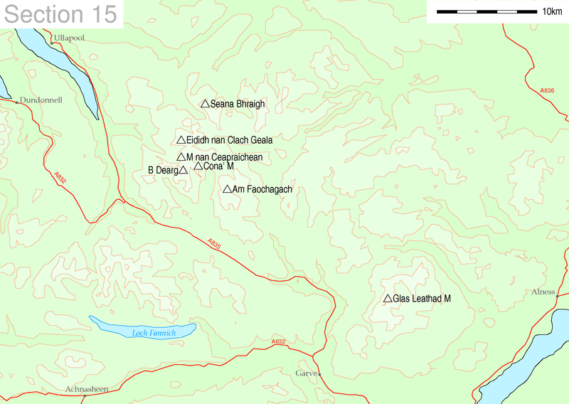
4 hills out of 7 can be climbed using public transport
Ben
Wyvis - Glas Leathad Mor(1046m) ![]()
The SMC guide recommends starting the climb near Garbat which is about 7km north of Garve on the A835. Looking at the OS map it is clear that it should be possible to avoid any significant road walking by using a variety of country lanes and forest/ hillside tracks to reach the valley of the Allt a'Bhaealaich Mhoir and then climb to the summit by the top of An Cabar. The guide suggests a time of 3 hours from Garbat so presuming a return time of 4h 30min and a walk in/out time of about 3 to 4 hours this is clearly a reasonable option.
Garve is reach by the Inverness to Ullapool Citylink buses and the trains on the Inverness to Kyle of Lochalsh lines.
It might be possible to ask the driver of the Ullapool bus to stop at the car park at Gartan on the outward journey thus saving time.
Arrivals at Garve are at 0844 (bus) and 953 (train)
Departures from Garve are 1613 (train) 1727 Mon-Fri or 1807 Sat (bus) and 1849 train.
It is only possible to use public transport on weekdays as there is insufficient time between trains on Sundays.
Am
Faochagach (953m) ![]()
Cona'
Mheall (978m) ![]() and
Beinn
Dearg (1084m)
and
Beinn
Dearg (1084m) ![]()
These three hills lie north of the A835 so are accessible from the Inverness to Ullapool bus.
The nearest timing point is Aultguish Inn. The first bus from Inverness arrives at 08.56
However, it might be possible to persuade the driver to drop you off at Lochdrum. The three hills could then be climbed in a circuit (as shown in the "Pocket Mountains - Northern Highlands" guide). The time of this walk is given as 9 hours. Clearly, however, you won't be able to be back in time for the evening bus back to Inverness at 17.53.
Far better to alter the end of the walk from Loch a' Gharbhrain and walk south-east to the northern shore of Loch Glascarnoch. Follow the shore until you come to the track leading to a radio mast near Meall an Torcain. This leads directly back to the Aultguish Inn where the night can be spent. This will add about another 6 km to the distance for the suggested circuit; a long day but practical in mid summer.
Of course you could also base yourself at the Inn and climb the hills over two days.
Meall
nan Ceapraichean (977m) ![]()
Eididh
nan Clach Geala (927m)![]()
These two hills should, theoretically, be possible to climb using public transport. However, whilst they can be reached using the Inverness to Ullapool bus escaping back to civilisation after the walk is another matter. Whilst I've included details of how this problem might be overcome I've decided not to count them as being accessible.
These hills are climbed from Inverael on the A835 at the head of Loch Broom. The Inverness to Ullapool bus passes Inverlael and might stop there. The return time from Inverael is just under 8 hours. The problem is now how to get back to civilisation. The only escape route would be along the A835 to Ullapool. This does not look, at least on the map, to be a particularly safe or pleasant route and is 10km long.
If the bus driver won't stop at Inverael another alternative would be to get off at Braemore Junction which is a recognised stop. Then following the tracks marked in black in the SMC guide through the woods by the Corrieshalloch Gorge the alternative route to Beinn Dearg could be followed via lorguill. There remains the same problem once you get back to Inverael.
One possibility might be to order a taxi; there is a public phone box at Inverael.
Seana
Bhraigh (926m) ![]()
No public transport option.
Section 16 Coigach to Cape Wrath
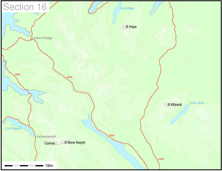
2 hills out of 4 hills can be climbed using public transport
Ben
More Assynt (998m) ![]() and Conival (987m)
and Conival (987m)
![]()
The route to both these hills starts at the Inchnadamph Hotel.
This can be reached by the Inverness to Durness bus operated by Tim Dearman. It leaves Inverness at 08.50 and arrives at the hotel at 11.27. The return walk is between 6 to 7 hours so clearly there should be plenty of time to complete the walk on the day of arrival .
There is also a later journey by train at 10.38 to Lairg and then by Postbus arriving at the hotel at 13.30 (how long this will continue is of course debatable). Finally the 15.00 Citylink bus is supposed to connect into a Drumbeg service at Ullapool arriving at 17.11.
In the opposite direction the through bus is at 17.35 arriving at Inverness at 19.44. Clearly you would also have plenty of time to complete the walk before catching the evening bus back to Inverness.
There are also two other services using post buses and service buses via Lairg. Hotel dep 09.20 arriving Inverness at 13.03 or via Ullapool Hotel dep 13.40 Inverness arrive 18.00.
Ben
Kilbreck (962m) ![]()
Ben
Hope (927m) ![]()
No public transport options
5 hills out of 13 can be climbed using public transport.
MULL
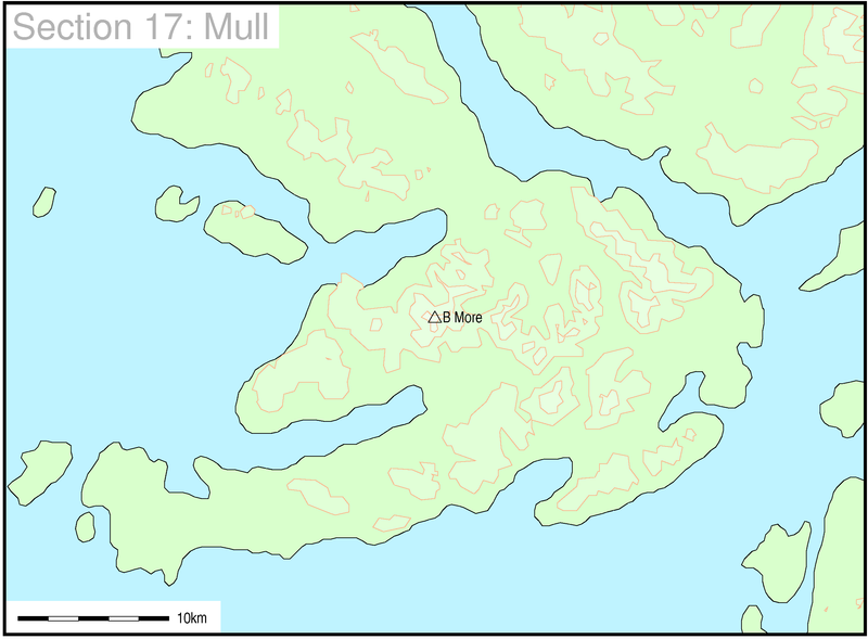
Ben More (966m) ![]()
Climbing Ben More from the north at Dhiseig entails a very long walk in from the nearest bus route at Salen. However, the Craignure to Fionnphort bus service passes much closer. The first Calmac ferry leaves Oban at 07.45 and connects at Craignure with 08.35 bus which reaches the junction of the A849/ B8035 - called Kinloch Crossroads at 09.05. The return bus is at 16.05 with a ferry connection at 17.00 to Oban.
A route that has been suggested by a walker on Scottish Hills is to start at 520297 and walk more or less north, angling NNE after Maol nan Damh and climb onto the south ridge of Ben More. He reported that it was easily climbed between the first and last bus.
To make the day more relaxing I'd be inclined to stay on the island and head across to Fionnphort or Iona for the night. There's a 17.25 bus to Fionnphort from the road junction.
SKYE

Sgurr nan Gillean (964m) ![]()
Am Basteir (934m) ![]()
Bruach na Frithe (958m) ![]()
The SMC recommends routes starting from or near the Sligachan Hotel.
Sligachan has good Citylink connections from Glasgow, Inverness which pass through Kyle of Lochalsh (rail connection to Inverness) as well Stagecoach buses between Portree and Broadford and Armadale. For much of the day the combined service is virtually hourly.
Sgurr
a' Mhadaidh (918m) ![]()
Sgurr
a' Ghreadaidh (973m) ![]()
Sgurr
na Banachdich (965m) ![]()
Sgurr
Dearg - The Inaccessible Pinacle (986m) ![]()
Sgurr
Mhic Choinnich (948m) ![]()
Sgurr
Alasdair (992m) ![]()
Sgurr
Dubh Mor (944m) ![]()
Sgurr
nan Eag (924m) ![]()
No public transport is available.
All of these hills are accessed from Glenbrittle. Unfortunately the summer only bus from Portree no longer appears to be running. The nearest bus stop now is at Carbost which is eight miles away.
For those intrepid souls who still wish to reach Glenbrittle service 53 from Portree to Fiscavaig runs about four times a day Monday to Friday and once on Saturdays.
From Sligachan the bus are at 08.36 (not schooldays), 11.19 (summer only), 13.19 (Mon-Fri), 15.53 (schooldays), 17.58 (Saturdays) and 18.03 (Mon-Fri).
From Carbost the return buses leave at 08.10, 09.35, 12.05 (summer) and 16.05 (all Mon-Fri) and 11.35 (Saturdays)
Bla Bheinn (928m) ![]()
The Broadford to Elgol stagecoach service 49 bus passes the starting point for this walk just beyond the village of Torrin. No doubt the driver would drop you off exactly where you require. The SMC guide suggests a time of 2h 20 minutes to the summit so a return time of about 4 hours seems practical. There is a 07.10 service (Mon- Sat) as well as a 07.30 (schooldays) bus from Broadford. Returns are at 12.13 (Saturdays only) and 14.38 and 17.23 (Mon-Fri).
Saturday seems the best day to do this walk at 5 hours should be plenty of time to do the walk.
Of course if you're there on a weekday you could also do the round bus trip to Elgol and Glasnakillie to fill in time. You'd see a bit more of Skye and not have such a long time to wait. This leaves Torrin at 13.36 for Glasnakillie before returning as the service for the 14.38 to Broadford
Another website with details about climbing Scottish hilles using public transport for access (not just Munros and not just the Highlands) is run by Alison Fox
Click here to go to her website
www.scottishhillsbybusandtrain.co.uk
![]()